You are here: Home > Network List > US - United States National Seismic Network Stations List
> Station AMTX Amarillo, Texas, USA > Earthquake Result Viewer
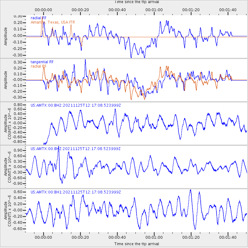
AMTX Amarillo, Texas, USA - Earthquake Result Viewer
*The percent match for this event was below the threshold and hence no stack was calculated.
| Earthquake location: |
Santa Cruz Islands |
| Earthquake latitude/longitude: |
-10.7/166.5 |
| Earthquake time(UTC): |
2021/11/25 (329) 12:04:10 GMT |
| Earthquake Depth: |
40 km |
| Earthquake Magnitude: |
6.0 mww |
| Earthquake Catalog/Contributor: |
NEIC PDE/us |
|
| Network: |
US United States National Seismic Network |
| Station: |
AMTX Amarillo, Texas, USA |
| Lat/Lon: |
34.53 N/101.41 W |
| Elevation: |
1010 m |
|
| Distance: |
97.7 deg |
| Az: |
56.366 deg |
| Baz: |
262.312 deg |
| Ray Param: |
$rayparam |
*The percent match for this event was below the threshold and hence was not used in the summary stack. |
|
| Radial Match: |
57.870174 % |
| Radial Bump: |
400 |
| Transverse Match: |
48.78854 % |
| Transverse Bump: |
400 |
| SOD ConfigId: |
26694651 |
| Insert Time: |
2021-12-09 12:21:58.549 +0000 |
| GWidth: |
2.5 |
| Max Bumps: |
400 |
| Tol: |
0.001 |
|
Signal To Noise
| Channel | StoN | STA | LTA |
| US:AMTX:00:BHZ:20211125T12:17:08.523999Z | 1.1275887 | 2.431156E-7 | 2.1560663E-7 |
| US:AMTX:00:BH1:20211125T12:17:08.523999Z | 1.3972355 | 3.3143675E-7 | 2.3720894E-7 |
| US:AMTX:00:BH2:20211125T12:17:08.523999Z | 0.6957524 | 2.4114763E-7 | 3.465998E-7 |
| Arrivals |
| Ps | |
| PpPs | |
| PsPs/PpSs | |


