You are here: Home > Network List > US - United States National Seismic Network Stations List
> Station MSO Missoula, Montana, USA > Earthquake Result Viewer
MSO Missoula, Montana, USA - Earthquake Result Viewer
| Earthquake location: |
Hawaii |
| Earthquake latitude/longitude: |
19.4/-155.0 |
| Earthquake time(UTC): |
2018/05/04 (124) 22:32:55 GMT |
| Earthquake Depth: |
5.0 km |
| Earthquake Magnitude: |
5.8 Ml |
| Earthquake Catalog/Contributor: |
NEIC PDE/us |
|
| Network: |
US United States National Seismic Network |
| Station: |
MSO Missoula, Montana, USA |
| Lat/Lon: |
46.83 N/113.94 W |
| Elevation: |
1264 m |
|
| Distance: |
43.3 deg |
| Az: |
41.186 deg |
| Baz: |
244.881 deg |
| Ray Param: |
0.07267953 |
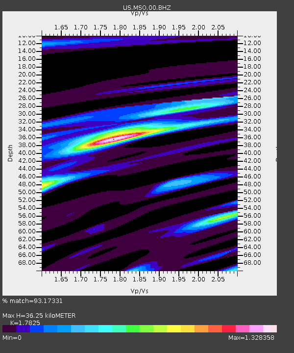
| Estimated Moho Depth: |
36.25 km |
| Estimated Crust Vp/Vs: |
1.78 |
| Assumed Crust Vp: |
6.353 km/s |
| Estimated Crust Vs: |
3.564 km/s |
| Estimated Crust Poisson's Ratio: |
0.27 |
|
| Radial Match: |
93.17331 % |
| Radial Bump: |
384 |
| Transverse Match: |
68.94347 % |
| Transverse Bump: |
400 |
| SOD ConfigId: |
2665671 |
| Insert Time: |
2018-05-18 22:39:57.426 +0000 |
| GWidth: |
2.5 |
| Max Bumps: |
400 |
| Tol: |
0.001 |
|
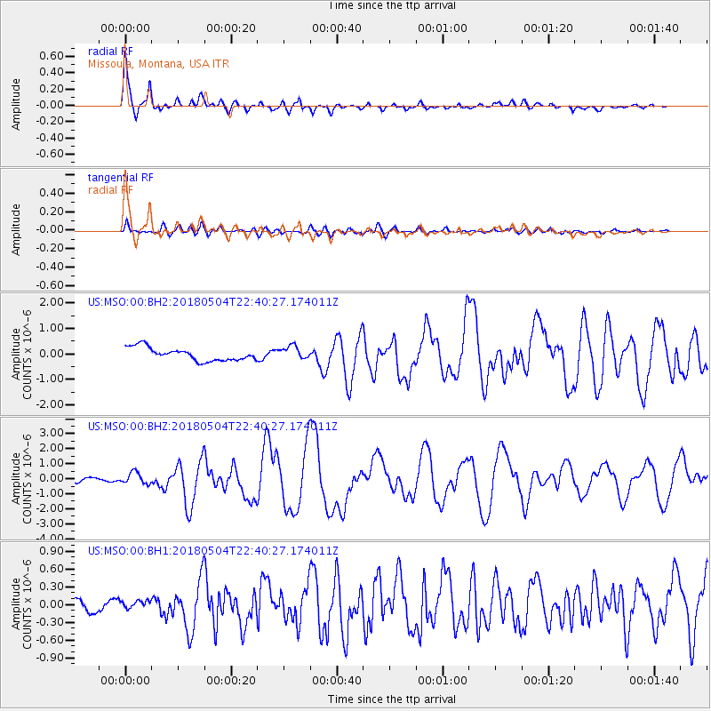
Signal To Noise
| Channel | StoN | STA | LTA |
| US:MSO:00:BHZ:20180504T22:40:27.174011Z | 2.6117747 | 3.869497E-7 | 1.4815585E-7 |
| US:MSO:00:BH1:20180504T22:40:27.174011Z | 0.75147384 | 6.8453495E-8 | 9.109232E-8 |
| US:MSO:00:BH2:20180504T22:40:27.174011Z | 1.0197293 | 2.5709605E-7 | 2.5212188E-7 |
| Arrivals |
| Ps | 4.8 SECOND |
| PpPs | 15 SECOND |
| PsPs/PpSs | 20 SECOND |


