You are here: Home > Network List > UW - Pacific Northwest Regional Seismic Network Stations List
> Station IRON Crane, OR, USA > Earthquake Result Viewer
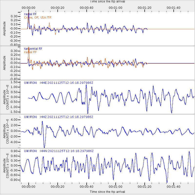
IRON Crane, OR, USA - Earthquake Result Viewer
*The percent match for this event was below the threshold and hence no stack was calculated.
| Earthquake location: |
Santa Cruz Islands |
| Earthquake latitude/longitude: |
-10.7/166.5 |
| Earthquake time(UTC): |
2021/11/25 (329) 12:04:10 GMT |
| Earthquake Depth: |
40 km |
| Earthquake Magnitude: |
6.0 mww |
| Earthquake Catalog/Contributor: |
NEIC PDE/us |
|
| Network: |
UW Pacific Northwest Regional Seismic Network |
| Station: |
IRON Crane, OR, USA |
| Lat/Lon: |
43.36 N/118.47 W |
| Elevation: |
1226 m |
|
| Distance: |
86.7 deg |
| Az: |
44.899 deg |
| Baz: |
251.99 deg |
| Ray Param: |
$rayparam |
*The percent match for this event was below the threshold and hence was not used in the summary stack. |
|
| Radial Match: |
79.5368 % |
| Radial Bump: |
400 |
| Transverse Match: |
57.295586 % |
| Transverse Bump: |
400 |
| SOD ConfigId: |
26694651 |
| Insert Time: |
2021-12-09 12:22:56.131 +0000 |
| GWidth: |
2.5 |
| Max Bumps: |
400 |
| Tol: |
0.001 |
|
Signal To Noise
| Channel | StoN | STA | LTA |
| UW:IRON: :HHZ:20211125T12:16:18.297986Z | 1.8182608 | 6.986728E-7 | 3.8425335E-7 |
| UW:IRON: :HHN:20211125T12:16:18.297986Z | 1.7253761 | 3.3718803E-7 | 1.954287E-7 |
| UW:IRON: :HHE:20211125T12:16:18.297986Z | 1.4469714 | 4.007109E-7 | 2.7693076E-7 |
| Arrivals |
| Ps | |
| PpPs | |
| PsPs/PpSs | |


