You are here: Home > Network List > UW - Pacific Northwest Regional Seismic Network Stations List
> Station YACT Yacolt, WA, USA > Earthquake Result Viewer
YACT Yacolt, WA, USA - Earthquake Result Viewer
| Earthquake location: |
Santa Cruz Islands |
| Earthquake latitude/longitude: |
-10.7/166.5 |
| Earthquake time(UTC): |
2021/11/25 (329) 12:04:10 GMT |
| Earthquake Depth: |
40 km |
| Earthquake Magnitude: |
6.0 mww |
| Earthquake Catalog/Contributor: |
NEIC PDE/us |
|
| Network: |
UW Pacific Northwest Regional Seismic Network |
| Station: |
YACT Yacolt, WA, USA |
| Lat/Lon: |
45.93 N/122.42 W |
| Elevation: |
214 m |
|
| Distance: |
84.9 deg |
| Az: |
41.524 deg |
| Baz: |
248.977 deg |
| Ray Param: |
0.045122035 |
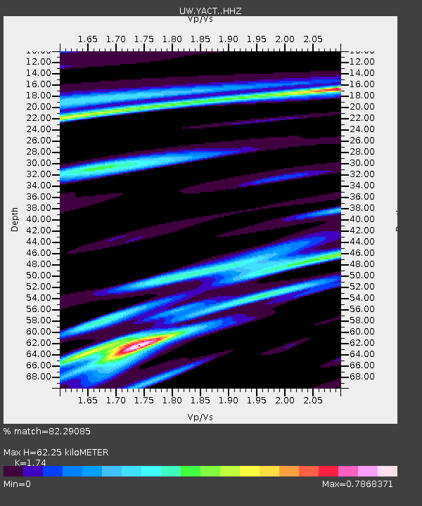
| Estimated Moho Depth: |
62.25 km |
| Estimated Crust Vp/Vs: |
1.74 |
| Assumed Crust Vp: |
6.566 km/s |
| Estimated Crust Vs: |
3.774 km/s |
| Estimated Crust Poisson's Ratio: |
0.25 |
|
| Radial Match: |
82.29085 % |
| Radial Bump: |
390 |
| Transverse Match: |
72.751205 % |
| Transverse Bump: |
400 |
| SOD ConfigId: |
26694651 |
| Insert Time: |
2021-12-09 12:23:29.294 +0000 |
| GWidth: |
2.5 |
| Max Bumps: |
400 |
| Tol: |
0.001 |
|
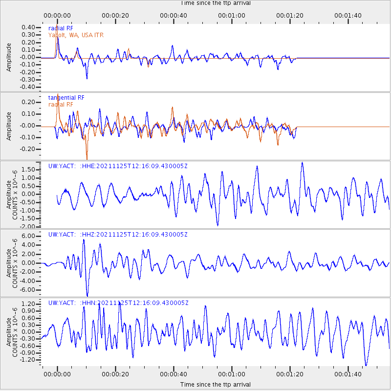
Signal To Noise
| Channel | StoN | STA | LTA |
| UW:YACT: :HHZ:20211125T12:16:09.430005Z | 2.4060133 | 6.7338317E-7 | 2.7987508E-7 |
| UW:YACT: :HHN:20211125T12:16:09.430005Z | 1.1627231 | 4.1402524E-7 | 3.5608244E-7 |
| UW:YACT: :HHE:20211125T12:16:09.430005Z | 0.43185285 | 1.8806463E-7 | 4.3548312E-7 |
| Arrivals |
| Ps | 7.2 SECOND |
| PpPs | 25 SECOND |
| PsPs/PpSs | 33 SECOND |


