You are here: Home > Network List > CN - Canadian National Seismograph Network Stations List
> Station INK INUVIK, NT > Earthquake Result Viewer
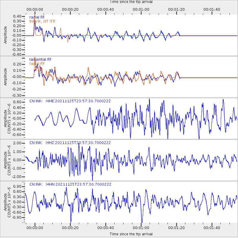
INK INUVIK, NT - Earthquake Result Viewer
*The percent match for this event was below the threshold and hence no stack was calculated.
| Earthquake location: |
Myanmar-India Border Region |
| Earthquake latitude/longitude: |
22.8/93.5 |
| Earthquake time(UTC): |
2021/11/25 (329) 23:45:41 GMT |
| Earthquake Depth: |
42 km |
| Earthquake Magnitude: |
5.8 mww |
| Earthquake Catalog/Contributor: |
NEIC PDE/us |
|
| Network: |
CN Canadian National Seismograph Network |
| Station: |
INK INUVIK, NT |
| Lat/Lon: |
68.31 N/133.53 W |
| Elevation: |
44 m |
|
| Distance: |
82.9 deg |
| Az: |
15.911 deg |
| Baz: |
317.122 deg |
| Ray Param: |
$rayparam |
*The percent match for this event was below the threshold and hence was not used in the summary stack. |
|
| Radial Match: |
72.10086 % |
| Radial Bump: |
400 |
| Transverse Match: |
56.038677 % |
| Transverse Bump: |
400 |
| SOD ConfigId: |
26694651 |
| Insert Time: |
2021-12-09 23:52:41.292 +0000 |
| GWidth: |
2.5 |
| Max Bumps: |
400 |
| Tol: |
0.001 |
|
Signal To Noise
| Channel | StoN | STA | LTA |
| CN:INK: :HHZ:20211125T23:57:30.700022Z | 3.3236072 | 5.3375214E-7 | 1.6059423E-7 |
| CN:INK: :HHN:20211125T23:57:30.700022Z | 1.3229089 | 3.1876948E-7 | 2.4096101E-7 |
| CN:INK: :HHE:20211125T23:57:30.700022Z | 1.5528004 | 2.5571967E-7 | 1.6468289E-7 |
| Arrivals |
| Ps | |
| PpPs | |
| PsPs/PpSs | |


