You are here: Home > Network List > G - GEOSCOPE Stations List
> Station INU Inuyama, Japan > Earthquake Result Viewer
INU Inuyama, Japan - Earthquake Result Viewer
*The percent match for this event was below the threshold and hence no stack was calculated.
| Earthquake location: |
Myanmar-India Border Region |
| Earthquake latitude/longitude: |
22.8/93.5 |
| Earthquake time(UTC): |
2021/11/25 (329) 23:45:41 GMT |
| Earthquake Depth: |
42 km |
| Earthquake Magnitude: |
5.8 mww |
| Earthquake Catalog/Contributor: |
NEIC PDE/us |
|
| Network: |
G GEOSCOPE |
| Station: |
INU Inuyama, Japan |
| Lat/Lon: |
35.35 N/137.03 E |
| Elevation: |
132 m |
|
| Distance: |
39.7 deg |
| Az: |
61.699 deg |
| Baz: |
263.678 deg |
| Ray Param: |
$rayparam |
*The percent match for this event was below the threshold and hence was not used in the summary stack. |
|
| Radial Match: |
73.40178 % |
| Radial Bump: |
400 |
| Transverse Match: |
75.50686 % |
| Transverse Bump: |
400 |
| SOD ConfigId: |
26694651 |
| Insert Time: |
2021-12-09 23:53:24.781 +0000 |
| GWidth: |
2.5 |
| Max Bumps: |
400 |
| Tol: |
0.001 |
|
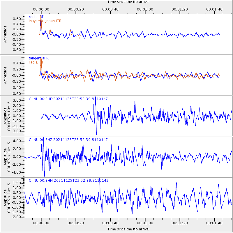
Signal To Noise
| Channel | StoN | STA | LTA |
| G:INU:00:BHZ:20211125T23:52:39.811014Z | 8.205451 | 2.2232243E-6 | 2.7094478E-7 |
| G:INU:00:BHN:20211125T23:52:39.811014Z | 1.2939659 | 5.067192E-7 | 3.9160162E-7 |
| G:INU:00:BHE:20211125T23:52:39.811014Z | 5.191027 | 1.5180972E-6 | 2.924464E-7 |
| Arrivals |
| Ps | |
| PpPs | |
| PsPs/PpSs | |


