You are here: Home > Network List > GE - GEOFON Stations List
> Station EIL GEOFON Station Eilat, Israel > Earthquake Result Viewer
EIL GEOFON Station Eilat, Israel - Earthquake Result Viewer
| Earthquake location: |
Myanmar-India Border Region |
| Earthquake latitude/longitude: |
22.8/93.5 |
| Earthquake time(UTC): |
2021/11/25 (329) 23:45:41 GMT |
| Earthquake Depth: |
42 km |
| Earthquake Magnitude: |
5.8 mww |
| Earthquake Catalog/Contributor: |
NEIC PDE/us |
|
| Network: |
GE GEOFON |
| Station: |
EIL GEOFON Station Eilat, Israel |
| Lat/Lon: |
29.67 N/34.95 E |
| Elevation: |
210 m |
|
| Distance: |
52.5 deg |
| Az: |
290.63 deg |
| Baz: |
82.888 deg |
| Ray Param: |
0.06662755 |
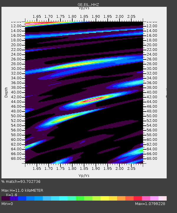
| Estimated Moho Depth: |
11.0 km |
| Estimated Crust Vp/Vs: |
1.60 |
| Assumed Crust Vp: |
6.472 km/s |
| Estimated Crust Vs: |
4.045 km/s |
| Estimated Crust Poisson's Ratio: |
0.18 |
|
| Radial Match: |
93.702736 % |
| Radial Bump: |
400 |
| Transverse Match: |
74.9503 % |
| Transverse Bump: |
400 |
| SOD ConfigId: |
26694651 |
| Insert Time: |
2021-12-09 23:53:50.442 +0000 |
| GWidth: |
2.5 |
| Max Bumps: |
400 |
| Tol: |
0.001 |
|

Signal To Noise
| Channel | StoN | STA | LTA |
| GE:EIL: :HHZ:20211125T23:54:19.859995Z | 5.506695 | 2.9030414E-7 | 5.2718402E-8 |
| GE:EIL: :HHN:20211125T23:54:19.859995Z | 1.3010839 | 7.355262E-8 | 5.6531803E-8 |
| GE:EIL: :HHE:20211125T23:54:19.859995Z | 1.9011056 | 9.507621E-8 | 5.0011007E-8 |
| Arrivals |
| Ps | 1.1 SECOND |
| PpPs | 4.2 SECOND |
| PsPs/PpSs | 5.2 SECOND |


