You are here: Home > Network List > KO - Kandilli Observatory Digital Broadband Seismic Network Stations List
> Station BALB Balikesir-Turkiye > Earthquake Result Viewer
BALB Balikesir-Turkiye - Earthquake Result Viewer
| Earthquake location: |
Myanmar-India Border Region |
| Earthquake latitude/longitude: |
22.8/93.5 |
| Earthquake time(UTC): |
2021/11/25 (329) 23:45:41 GMT |
| Earthquake Depth: |
42 km |
| Earthquake Magnitude: |
5.8 mww |
| Earthquake Catalog/Contributor: |
NEIC PDE/us |
|
| Network: |
KO Kandilli Observatory Digital Broadband Seismic Network |
| Station: |
BALB Balikesir-Turkiye |
| Lat/Lon: |
39.64 N/27.88 E |
| Elevation: |
120 m |
|
| Distance: |
57.4 deg |
| Az: |
303.389 deg |
| Baz: |
86.222 deg |
| Ray Param: |
0.06344263 |
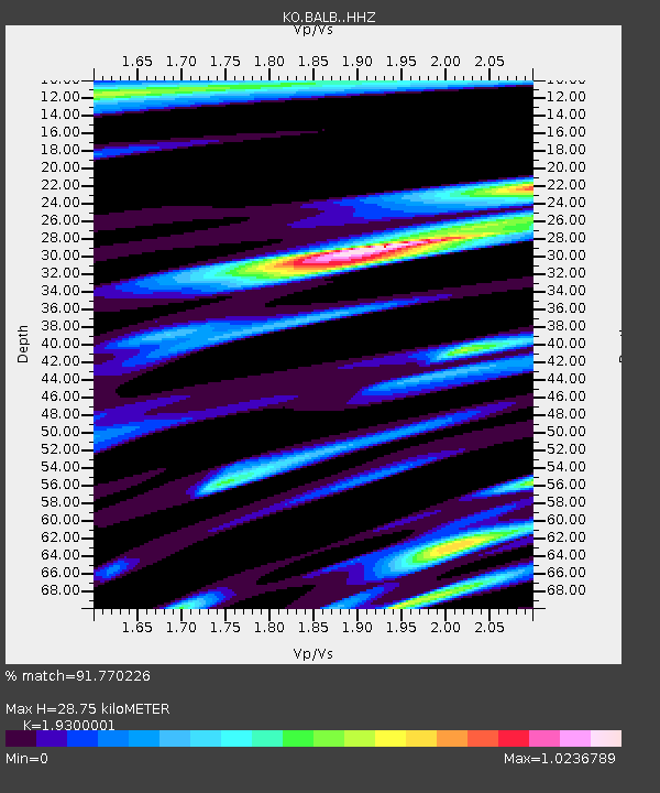
| Estimated Moho Depth: |
28.75 km |
| Estimated Crust Vp/Vs: |
1.93 |
| Assumed Crust Vp: |
6.155 km/s |
| Estimated Crust Vs: |
3.189 km/s |
| Estimated Crust Poisson's Ratio: |
0.32 |
|
| Radial Match: |
91.770226 % |
| Radial Bump: |
400 |
| Transverse Match: |
82.2589 % |
| Transverse Bump: |
400 |
| SOD ConfigId: |
26694651 |
| Insert Time: |
2021-12-09 23:55:30.133 +0000 |
| GWidth: |
2.5 |
| Max Bumps: |
400 |
| Tol: |
0.001 |
|

Signal To Noise
| Channel | StoN | STA | LTA |
| KO:BALB: :HHZ:20211125T23:54:55.109995Z | 6.7255416 | 4.7528445E-7 | 7.066857E-8 |
| KO:BALB: :HHN:20211125T23:54:55.109995Z | 1.6595905 | 1.4467524E-7 | 8.7175266E-8 |
| KO:BALB: :HHE:20211125T23:54:55.109995Z | 2.2587202 | 1.7787387E-7 | 7.874985E-8 |
| Arrivals |
| Ps | 4.5 SECOND |
| PpPs | 13 SECOND |
| PsPs/PpSs | 18 SECOND |


