You are here: Home > Network List > C8 - Canadian Seismic Research Network () Stations List
> Station GRIB Gribbell Island, BC, CA > Earthquake Result Viewer
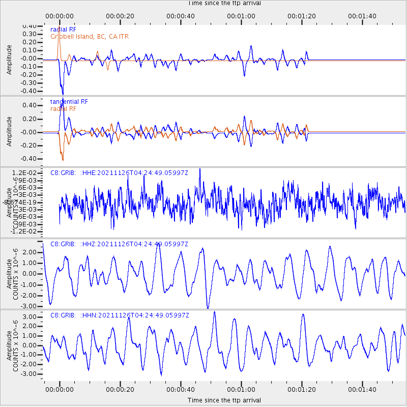
GRIB Gribbell Island, BC, CA - Earthquake Result Viewer
*The percent match for this event was below the threshold and hence no stack was calculated.
| Earthquake location: |
Vanuatu Islands Region |
| Earthquake latitude/longitude: |
-21.4/174.5 |
| Earthquake time(UTC): |
2021/11/26 (330) 04:13:21 GMT |
| Earthquake Depth: |
520 km |
| Earthquake Magnitude: |
5.8 Mww |
| Earthquake Catalog/Contributor: |
NEIC PDE/us |
|
| Network: |
C8 Canadian Seismic Research Network () |
| Station: |
GRIB Gribbell Island, BC, CA |
| Lat/Lon: |
53.34 N/129.14 W |
| Elevation: |
418 m |
|
| Distance: |
88.9 deg |
| Az: |
29.965 deg |
| Baz: |
230.899 deg |
| Ray Param: |
$rayparam |
*The percent match for this event was below the threshold and hence was not used in the summary stack. |
|
| Radial Match: |
69.96323 % |
| Radial Bump: |
400 |
| Transverse Match: |
69.914314 % |
| Transverse Bump: |
400 |
| SOD ConfigId: |
26694651 |
| Insert Time: |
2021-12-10 04:19:10.782 +0000 |
| GWidth: |
2.5 |
| Max Bumps: |
400 |
| Tol: |
0.001 |
|
Signal To Noise
| Channel | StoN | STA | LTA |
| C8:GRIB: :HHZ:20211126T04:24:49.05997Z | 0.5169933 | 9.685815E-7 | 1.8734896E-6 |
| C8:GRIB: :HHN:20211126T04:24:49.05997Z | 0.70820403 | 8.297629E-7 | 1.1716439E-6 |
| C8:GRIB: :HHE:20211126T04:24:49.05997Z | 1.1080785 | 3.991636E-9 | 3.6023045E-9 |
| Arrivals |
| Ps | |
| PpPs | |
| PsPs/PpSs | |


