You are here: Home > Network List > CI - Caltech Regional Seismic Network Stations List
> Station MPM Manuel Prospect Mine, California, USA > Earthquake Result Viewer
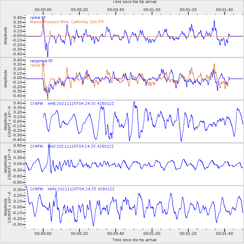
MPM Manuel Prospect Mine, California, USA - Earthquake Result Viewer
*The percent match for this event was below the threshold and hence no stack was calculated.
| Earthquake location: |
Vanuatu Islands Region |
| Earthquake latitude/longitude: |
-21.4/174.5 |
| Earthquake time(UTC): |
2021/11/26 (330) 04:13:21 GMT |
| Earthquake Depth: |
520 km |
| Earthquake Magnitude: |
5.8 Mww |
| Earthquake Catalog/Contributor: |
NEIC PDE/us |
|
| Network: |
CI Caltech Regional Seismic Network |
| Station: |
MPM Manuel Prospect Mine, California, USA |
| Lat/Lon: |
36.06 N/117.49 W |
| Elevation: |
185 m |
|
| Distance: |
86.0 deg |
| Az: |
48.877 deg |
| Baz: |
240.017 deg |
| Ray Param: |
$rayparam |
*The percent match for this event was below the threshold and hence was not used in the summary stack. |
|
| Radial Match: |
61.87642 % |
| Radial Bump: |
400 |
| Transverse Match: |
49.51098 % |
| Transverse Bump: |
400 |
| SOD ConfigId: |
26694651 |
| Insert Time: |
2021-12-10 04:20:44.744 +0000 |
| GWidth: |
2.5 |
| Max Bumps: |
400 |
| Tol: |
0.001 |
|
Signal To Noise
| Channel | StoN | STA | LTA |
| CI:MPM: :HHZ:20211126T04:24:35.428012Z | 4.191472 | 3.7265386E-7 | 8.890764E-8 |
| CI:MPM: :HHN:20211126T04:24:35.428012Z | 0.4734949 | 8.5578534E-8 | 1.8073803E-7 |
| CI:MPM: :HHE:20211126T04:24:35.428012Z | 2.0269372 | 2.6379027E-7 | 1.301423E-7 |
| Arrivals |
| Ps | |
| PpPs | |
| PsPs/PpSs | |


