You are here: Home > Network List > AG - Arkansas Seismic Network Stations List
> Station XB02 XB02 > Earthquake Result Viewer
XB02 XB02 - Earthquake Result Viewer
| Earthquake location: |
Northern Peru |
| Earthquake latitude/longitude: |
-4.5/-76.7 |
| Earthquake time(UTC): |
2021/11/28 (332) 10:52:14 GMT |
| Earthquake Depth: |
99 km |
| Earthquake Magnitude: |
7.4 Mi |
| Earthquake Catalog/Contributor: |
NEIC PDE/at |
|
| Network: |
AG Arkansas Seismic Network |
| Station: |
XB02 XB02 |
| Lat/Lon: |
33.20 N/92.49 W |
| Elevation: |
69 m |
|
| Distance: |
40.4 deg |
| Az: |
339.374 deg |
| Baz: |
155.237 deg |
| Ray Param: |
0.074109435 |
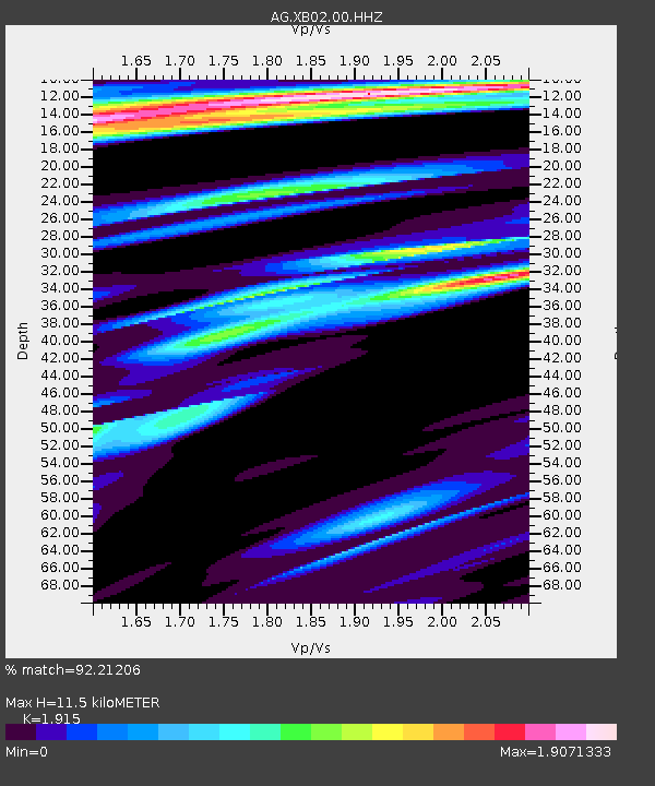
| Estimated Moho Depth: |
11.5 km |
| Estimated Crust Vp/Vs: |
1.91 |
| Assumed Crust Vp: |
6.245 km/s |
| Estimated Crust Vs: |
3.261 km/s |
| Estimated Crust Poisson's Ratio: |
0.31 |
|
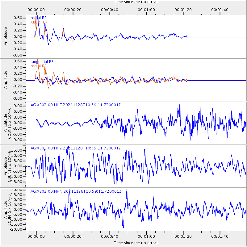
| Radial Match: |
92.21206 % |
| Radial Bump: |
359 |
| Transverse Match: |
70.73266 % |
| Transverse Bump: |
400 |
| SOD ConfigId: |
26694651 |
| Insert Time: |
2021-12-12 10:54:07.520 +0000 |
| GWidth: |
2.5 |
| Max Bumps: |
400 |
| Tol: |
0.001 |
|
Signal To Noise
| Channel | StoN | STA | LTA |
| AG:XB02:00:HHZ:20211128T10:59:11.720001Z | 15.50399 | 7.605748E-6 | 4.905672E-7 |
| AG:XB02:00:HHN:20211128T10:59:11.720001Z | 3.19839 | 2.7184378E-6 | 8.4993945E-7 |
| AG:XB02:00:HHE:20211128T10:59:11.720001Z | 1.7648586 | 1.4684683E-6 | 8.3206004E-7 |
| Arrivals |
| Ps | 1.8 SECOND |
| PpPs | 5.1 SECOND |
| PsPs/PpSs | 6.8 SECOND |


