You are here: Home > Network List > AK - Alaska Regional Network Stations List
> Station F21K Alatna River, AK, USA > Earthquake Result Viewer
F21K Alatna River, AK, USA - Earthquake Result Viewer
| Earthquake location: |
Northern Peru |
| Earthquake latitude/longitude: |
-4.5/-76.7 |
| Earthquake time(UTC): |
2021/11/28 (332) 10:52:14 GMT |
| Earthquake Depth: |
99 km |
| Earthquake Magnitude: |
7.4 Mi |
| Earthquake Catalog/Contributor: |
NEIC PDE/at |
|
| Network: |
AK Alaska Regional Network |
| Station: |
F21K Alatna River, AK, USA |
| Lat/Lon: |
67.22 N/153.48 W |
| Elevation: |
597 m |
|
| Distance: |
89.0 deg |
| Az: |
337.721 deg |
| Baz: |
103.906 deg |
| Ray Param: |
0.04195564 |
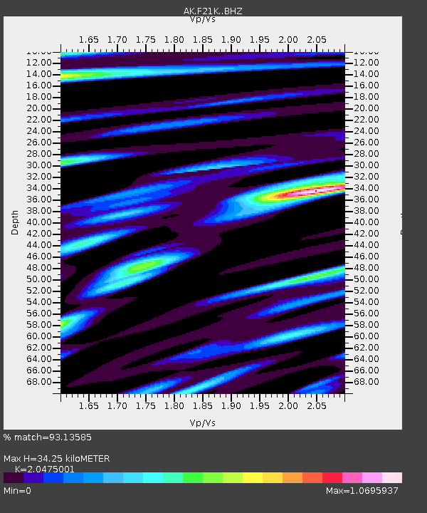
| Estimated Moho Depth: |
34.25 km |
| Estimated Crust Vp/Vs: |
2.05 |
| Assumed Crust Vp: |
6.455 km/s |
| Estimated Crust Vs: |
3.153 km/s |
| Estimated Crust Poisson's Ratio: |
0.34 |
|
| Radial Match: |
93.13585 % |
| Radial Bump: |
400 |
| Transverse Match: |
83.98599 % |
| Transverse Bump: |
400 |
| SOD ConfigId: |
26694651 |
| Insert Time: |
2021-12-12 10:55:24.684 +0000 |
| GWidth: |
2.5 |
| Max Bumps: |
400 |
| Tol: |
0.001 |
|

Signal To Noise
| Channel | StoN | STA | LTA |
| AK:F21K: :BHZ:20211128T11:04:26.679993Z | 12.650713 | 3.4718623E-6 | 2.7444005E-7 |
| AK:F21K: :BHN:20211128T11:04:26.679993Z | 2.1892128 | 5.081215E-7 | 2.321024E-7 |
| AK:F21K: :BHE:20211128T11:04:26.679993Z | 7.968782 | 1.1337872E-6 | 1.4227861E-7 |
| Arrivals |
| Ps | 5.7 SECOND |
| PpPs | 16 SECOND |
| PsPs/PpSs | 22 SECOND |


