You are here: Home > Network List > AK - Alaska Regional Network Stations List
> Station GRNC Granite Creek, AK, USA > Earthquake Result Viewer
GRNC Granite Creek, AK, USA - Earthquake Result Viewer
| Earthquake location: |
Northern Peru |
| Earthquake latitude/longitude: |
-4.5/-76.7 |
| Earthquake time(UTC): |
2021/11/28 (332) 10:52:14 GMT |
| Earthquake Depth: |
99 km |
| Earthquake Magnitude: |
7.4 Mi |
| Earthquake Catalog/Contributor: |
NEIC PDE/at |
|
| Network: |
AK Alaska Regional Network |
| Station: |
GRNC Granite Creek, AK, USA |
| Lat/Lon: |
60.73 N/141.76 W |
| Elevation: |
2116 m |
|
| Distance: |
82.0 deg |
| Az: |
333.262 deg |
| Baz: |
114.106 deg |
| Ray Param: |
0.046961863 |
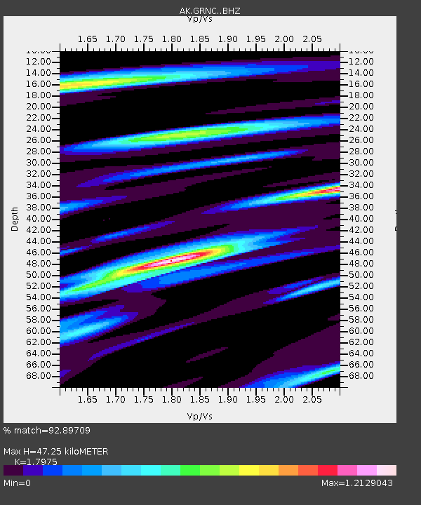
| Estimated Moho Depth: |
47.25 km |
| Estimated Crust Vp/Vs: |
1.80 |
| Assumed Crust Vp: |
6.566 km/s |
| Estimated Crust Vs: |
3.653 km/s |
| Estimated Crust Poisson's Ratio: |
0.28 |
|
| Radial Match: |
92.89709 % |
| Radial Bump: |
400 |
| Transverse Match: |
89.39332 % |
| Transverse Bump: |
400 |
| SOD ConfigId: |
26694651 |
| Insert Time: |
2021-12-12 10:55:48.329 +0000 |
| GWidth: |
2.5 |
| Max Bumps: |
400 |
| Tol: |
0.001 |
|

Signal To Noise
| Channel | StoN | STA | LTA |
| AK:GRNC: :BHZ:20211128T11:03:52.107971Z | 8.3012085 | 4.7910207E-6 | 5.771473E-7 |
| AK:GRNC: :BHN:20211128T11:03:52.107971Z | 3.5887606 | 1.1865176E-6 | 3.3062045E-7 |
| AK:GRNC: :BHE:20211128T11:03:52.107971Z | 4.9921155 | 1.415451E-6 | 2.8353733E-7 |
| Arrivals |
| Ps | 5.9 SECOND |
| PpPs | 20 SECOND |
| PsPs/PpSs | 25 SECOND |


