You are here: Home > Network List > AK - Alaska Regional Network Stations List
> Station I21K Tanana, AK, USA > Earthquake Result Viewer
I21K Tanana, AK, USA - Earthquake Result Viewer
| Earthquake location: |
Northern Peru |
| Earthquake latitude/longitude: |
-4.5/-76.7 |
| Earthquake time(UTC): |
2021/11/28 (332) 10:52:14 GMT |
| Earthquake Depth: |
99 km |
| Earthquake Magnitude: |
7.4 Mi |
| Earthquake Catalog/Contributor: |
NEIC PDE/at |
|
| Network: |
AK Alaska Regional Network |
| Station: |
I21K Tanana, AK, USA |
| Lat/Lon: |
65.18 N/151.98 W |
| Elevation: |
248 m |
|
| Distance: |
87.9 deg |
| Az: |
335.888 deg |
| Baz: |
105.23 deg |
| Ray Param: |
0.042765778 |
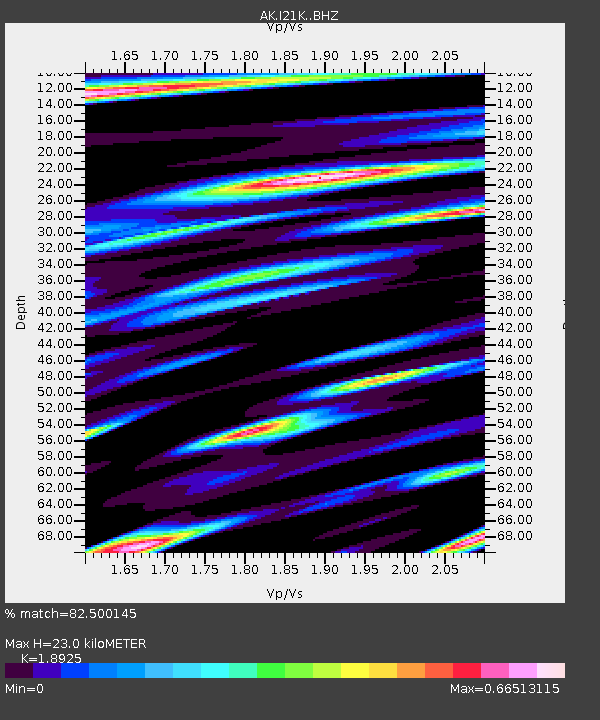
| Estimated Moho Depth: |
23.0 km |
| Estimated Crust Vp/Vs: |
1.89 |
| Assumed Crust Vp: |
6.566 km/s |
| Estimated Crust Vs: |
3.47 km/s |
| Estimated Crust Poisson's Ratio: |
0.31 |
|
| Radial Match: |
82.500145 % |
| Radial Bump: |
400 |
| Transverse Match: |
75.781555 % |
| Transverse Bump: |
400 |
| SOD ConfigId: |
26694651 |
| Insert Time: |
2021-12-12 10:56:06.650 +0000 |
| GWidth: |
2.5 |
| Max Bumps: |
400 |
| Tol: |
0.001 |
|

Signal To Noise
| Channel | StoN | STA | LTA |
| AK:I21K: :BHZ:20211128T11:04:21.47998Z | 11.286766 | 3.5017333E-6 | 3.1025127E-7 |
| AK:I21K: :BHN:20211128T11:04:21.47998Z | 2.6496284 | 8.350789E-7 | 3.151683E-7 |
| AK:I21K: :BHE:20211128T11:04:21.47998Z | 4.998903 | 1.3154918E-6 | 2.631561E-7 |
| Arrivals |
| Ps | 3.2 SECOND |
| PpPs | 9.9 SECOND |
| PsPs/PpSs | 13 SECOND |


