You are here: Home > Network List > AK - Alaska Regional Network Stations List
> Station L14K Kuka Creek, AK, USA > Earthquake Result Viewer
L14K Kuka Creek, AK, USA - Earthquake Result Viewer
| Earthquake location: |
Northern Peru |
| Earthquake latitude/longitude: |
-4.5/-76.7 |
| Earthquake time(UTC): |
2021/11/28 (332) 10:52:14 GMT |
| Earthquake Depth: |
99 km |
| Earthquake Magnitude: |
7.4 Mi |
| Earthquake Catalog/Contributor: |
NEIC PDE/at |
|
| Network: |
AK Alaska Regional Network |
| Station: |
L14K Kuka Creek, AK, USA |
| Lat/Lon: |
61.34 N/162.68 W |
| Elevation: |
41 m |
|
| Distance: |
92.0 deg |
| Az: |
331.238 deg |
| Baz: |
95.671 deg |
| Ray Param: |
0.04148935 |
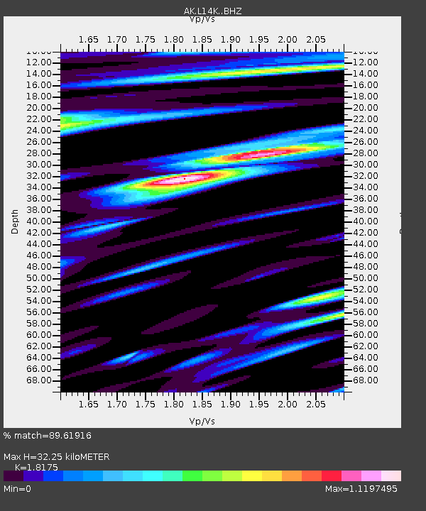
| Estimated Moho Depth: |
32.25 km |
| Estimated Crust Vp/Vs: |
1.82 |
| Assumed Crust Vp: |
6.1 km/s |
| Estimated Crust Vs: |
3.356 km/s |
| Estimated Crust Poisson's Ratio: |
0.28 |
|
| Radial Match: |
89.61916 % |
| Radial Bump: |
400 |
| Transverse Match: |
75.811005 % |
| Transverse Bump: |
400 |
| SOD ConfigId: |
26694651 |
| Insert Time: |
2021-12-12 10:56:38.891 +0000 |
| GWidth: |
2.5 |
| Max Bumps: |
400 |
| Tol: |
0.001 |
|

Signal To Noise
| Channel | StoN | STA | LTA |
| AK:L14K: :BHZ:20211128T11:04:40.359985Z | 8.283794 | 2.7359968E-6 | 3.3028303E-7 |
| AK:L14K: :BHN:20211128T11:04:40.359985Z | 1.2607918 | 3.3455413E-7 | 2.6535238E-7 |
| AK:L14K: :BHE:20211128T11:04:40.359985Z | 3.1867185 | 1.0327652E-6 | 3.2408425E-7 |
| Arrivals |
| Ps | 4.4 SECOND |
| PpPs | 15 SECOND |
| PsPs/PpSs | 19 SECOND |


