You are here: Home > Network List > AK - Alaska Regional Network Stations List
> Station MDM Murphy Dome > Earthquake Result Viewer
MDM Murphy Dome - Earthquake Result Viewer
| Earthquake location: |
Northern Peru |
| Earthquake latitude/longitude: |
-4.5/-76.7 |
| Earthquake time(UTC): |
2021/11/28 (332) 10:52:14 GMT |
| Earthquake Depth: |
99 km |
| Earthquake Magnitude: |
7.4 Mi |
| Earthquake Catalog/Contributor: |
NEIC PDE/at |
|
| Network: |
AK Alaska Regional Network |
| Station: |
MDM Murphy Dome |
| Lat/Lon: |
64.96 N/148.23 W |
| Elevation: |
634 m |
|
| Distance: |
86.3 deg |
| Az: |
336.14 deg |
| Baz: |
108.642 deg |
| Ray Param: |
0.043920375 |
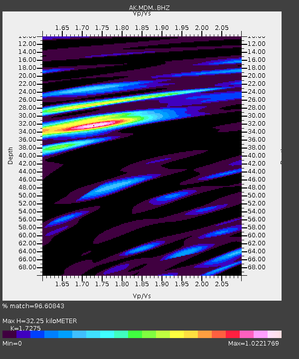
| Estimated Moho Depth: |
32.25 km |
| Estimated Crust Vp/Vs: |
1.73 |
| Assumed Crust Vp: |
6.566 km/s |
| Estimated Crust Vs: |
3.801 km/s |
| Estimated Crust Poisson's Ratio: |
0.25 |
|
| Radial Match: |
96.60843 % |
| Radial Bump: |
349 |
| Transverse Match: |
91.55774 % |
| Transverse Bump: |
389 |
| SOD ConfigId: |
26694651 |
| Insert Time: |
2021-12-12 10:57:06.849 +0000 |
| GWidth: |
2.5 |
| Max Bumps: |
400 |
| Tol: |
0.001 |
|
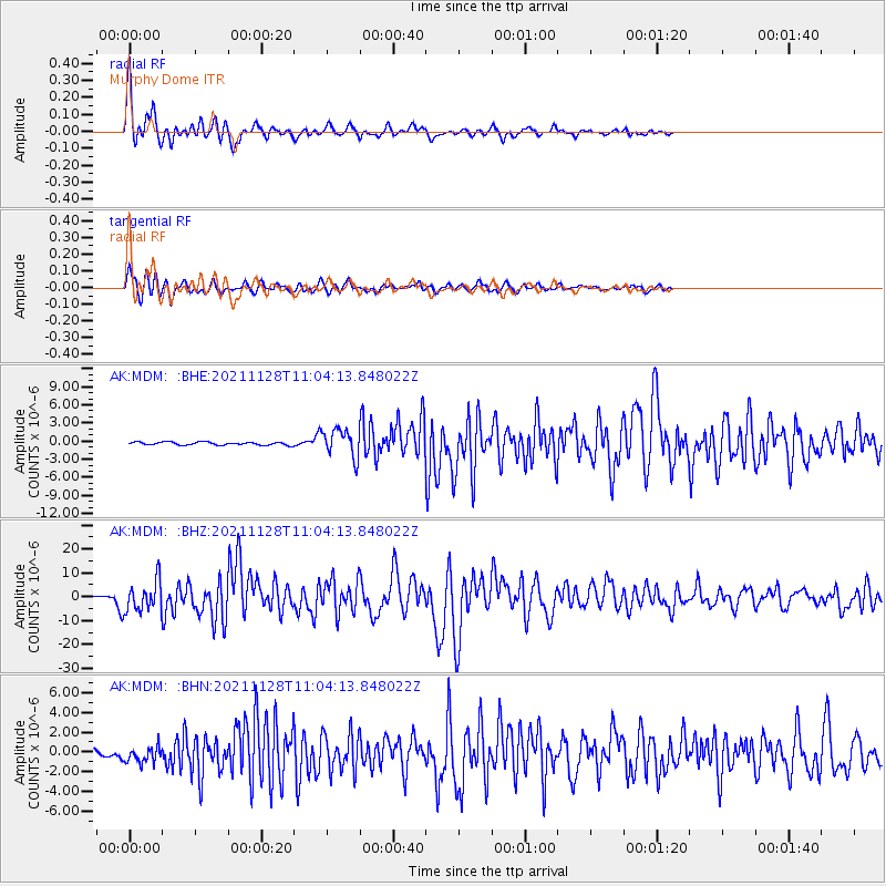
Signal To Noise
| Channel | StoN | STA | LTA |
| AK:MDM: :BHZ:20211128T11:04:13.848022Z | 26.855532 | 6.471639E-6 | 2.4097974E-7 |
| AK:MDM: :BHN:20211128T11:04:13.848022Z | 2.3703785 | 8.022743E-7 | 3.384583E-7 |
| AK:MDM: :BHE:20211128T11:04:13.848022Z | 9.219166 | 2.293165E-6 | 2.4873887E-7 |
| Arrivals |
| Ps | 3.7 SECOND |
| PpPs | 13 SECOND |
| PsPs/PpSs | 17 SECOND |


