You are here: Home > Network List > AK - Alaska Regional Network Stations List
> Station NICH Nichawak Mountain, AK, USA > Earthquake Result Viewer
NICH Nichawak Mountain, AK, USA - Earthquake Result Viewer
| Earthquake location: |
Northern Peru |
| Earthquake latitude/longitude: |
-4.5/-76.7 |
| Earthquake time(UTC): |
2021/11/28 (332) 10:52:14 GMT |
| Earthquake Depth: |
99 km |
| Earthquake Magnitude: |
7.4 Mi |
| Earthquake Catalog/Contributor: |
NEIC PDE/at |
|
| Network: |
AK Alaska Regional Network |
| Station: |
NICH Nichawak Mountain, AK, USA |
| Lat/Lon: |
60.24 N/143.97 W |
| Elevation: |
485 m |
|
| Distance: |
82.8 deg |
| Az: |
332.366 deg |
| Baz: |
112.064 deg |
| Ray Param: |
0.04639757 |
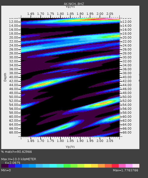
| Estimated Moho Depth: |
10.0 km |
| Estimated Crust Vp/Vs: |
2.10 |
| Assumed Crust Vp: |
6.566 km/s |
| Estimated Crust Vs: |
3.13 km/s |
| Estimated Crust Poisson's Ratio: |
0.35 |
|
| Radial Match: |
90.62966 % |
| Radial Bump: |
400 |
| Transverse Match: |
86.667885 % |
| Transverse Bump: |
400 |
| SOD ConfigId: |
26694651 |
| Insert Time: |
2021-12-12 10:57:16.406 +0000 |
| GWidth: |
2.5 |
| Max Bumps: |
400 |
| Tol: |
0.001 |
|

Signal To Noise
| Channel | StoN | STA | LTA |
| AK:NICH: :BHZ:20211128T11:03:56.328003Z | 7.907785 | 6.8682516E-6 | 8.6854305E-7 |
| AK:NICH: :BHN:20211128T11:03:56.328003Z | 1.5563473 | 1.5026785E-6 | 9.655162E-7 |
| AK:NICH: :BHE:20211128T11:03:56.328003Z | 1.7799097 | 1.685873E-6 | 9.4716773E-7 |
| Arrivals |
| Ps | 1.7 SECOND |
| PpPs | 4.6 SECOND |
| PsPs/PpSs | 6.3 SECOND |


