You are here: Home > Network List > AT - Alaska Tsunami Warning Seismic System Stations List
> Station PMR Palmer, Alaska > Earthquake Result Viewer
PMR Palmer, Alaska - Earthquake Result Viewer
| Earthquake location: |
Northern Peru |
| Earthquake latitude/longitude: |
-4.5/-76.7 |
| Earthquake time(UTC): |
2021/11/28 (332) 10:52:14 GMT |
| Earthquake Depth: |
99 km |
| Earthquake Magnitude: |
7.4 Mi |
| Earthquake Catalog/Contributor: |
NEIC PDE/at |
|
| Network: |
AT Alaska Tsunami Warning Seismic System |
| Station: |
PMR Palmer, Alaska |
| Lat/Lon: |
61.59 N/149.13 W |
| Elevation: |
100 m |
|
| Distance: |
85.7 deg |
| Az: |
332.792 deg |
| Baz: |
107.604 deg |
| Ray Param: |
0.04439523 |
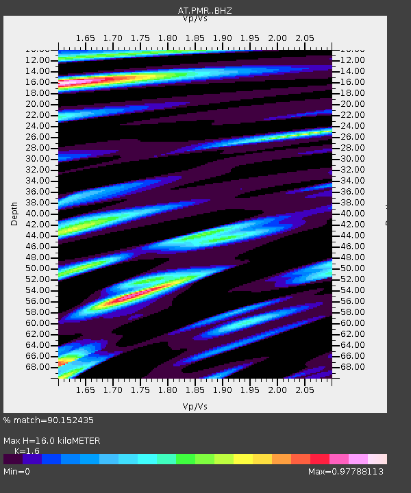
| Estimated Moho Depth: |
16.0 km |
| Estimated Crust Vp/Vs: |
1.60 |
| Assumed Crust Vp: |
6.566 km/s |
| Estimated Crust Vs: |
4.104 km/s |
| Estimated Crust Poisson's Ratio: |
0.18 |
|
| Radial Match: |
90.152435 % |
| Radial Bump: |
400 |
| Transverse Match: |
87.639854 % |
| Transverse Bump: |
400 |
| SOD ConfigId: |
26694651 |
| Insert Time: |
2021-12-12 10:58:51.513 +0000 |
| GWidth: |
2.5 |
| Max Bumps: |
400 |
| Tol: |
0.001 |
|

Signal To Noise
| Channel | StoN | STA | LTA |
| AT:PMR: :BHZ:20211128T11:04:10.599976Z | 15.309659 | 3.6363424E-6 | 2.3751949E-7 |
| AT:PMR: :BHN:20211128T11:04:10.599976Z | 2.7194228 | 5.7638124E-7 | 2.1194984E-7 |
| AT:PMR: :BHE:20211128T11:04:10.599976Z | 3.1482985 | 1.172421E-6 | 3.7239826E-7 |
| Arrivals |
| Ps | 1.5 SECOND |
| PpPs | 6.2 SECOND |
| PsPs/PpSs | 7.7 SECOND |


