You are here: Home > Network List > AV - Alaska Volcano Observatory Stations List
> Station AHB Akutan Harbor, Akutan Volcano, Alaska > Earthquake Result Viewer
AHB Akutan Harbor, Akutan Volcano, Alaska - Earthquake Result Viewer
| Earthquake location: |
Northern Peru |
| Earthquake latitude/longitude: |
-4.5/-76.7 |
| Earthquake time(UTC): |
2021/11/28 (332) 10:52:14 GMT |
| Earthquake Depth: |
99 km |
| Earthquake Magnitude: |
7.4 Mi |
| Earthquake Catalog/Contributor: |
NEIC PDE/at |
|
| Network: |
AV Alaska Volcano Observatory |
| Station: |
AHB Akutan Harbor, Akutan Volcano, Alaska |
| Lat/Lon: |
54.11 N/165.82 W |
| Elevation: |
447 m |
|
| Distance: |
93.1 deg |
| Az: |
323.875 deg |
| Baz: |
93.347 deg |
| Ray Param: |
0.04128391 |
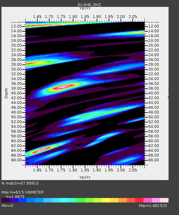
| Estimated Moho Depth: |
63.5 km |
| Estimated Crust Vp/Vs: |
1.67 |
| Assumed Crust Vp: |
5.989 km/s |
| Estimated Crust Vs: |
3.592 km/s |
| Estimated Crust Poisson's Ratio: |
0.22 |
|
| Radial Match: |
87.95915 % |
| Radial Bump: |
400 |
| Transverse Match: |
71.619896 % |
| Transverse Bump: |
400 |
| SOD ConfigId: |
26694651 |
| Insert Time: |
2021-12-12 10:59:01.483 +0000 |
| GWidth: |
2.5 |
| Max Bumps: |
400 |
| Tol: |
0.001 |
|

Signal To Noise
| Channel | StoN | STA | LTA |
| AV:AHB: :BHZ:20211128T11:04:45.440002Z | 2.879961 | 2.1779406E-6 | 7.562396E-7 |
| AV:AHB: :BHN:20211128T11:04:45.440002Z | 0.9845478 | 6.6534966E-7 | 6.7579214E-7 |
| AV:AHB: :BHE:20211128T11:04:45.440002Z | 1.9173169 | 1.2429713E-6 | 6.482868E-7 |
| Arrivals |
| Ps | 7.2 SECOND |
| PpPs | 28 SECOND |
| PsPs/PpSs | 35 SECOND |


