You are here: Home > Network List > AV - Alaska Volcano Observatory Stations List
> Station DT1 Dutton Round Hill, Mount Dutton, Alaska > Earthquake Result Viewer
DT1 Dutton Round Hill, Mount Dutton, Alaska - Earthquake Result Viewer
| Earthquake location: |
Northern Peru |
| Earthquake latitude/longitude: |
-4.5/-76.7 |
| Earthquake time(UTC): |
2021/11/28 (332) 10:52:14 GMT |
| Earthquake Depth: |
99 km |
| Earthquake Magnitude: |
7.4 Mi |
| Earthquake Catalog/Contributor: |
NEIC PDE/at |
|
| Network: |
AV Alaska Volcano Observatory |
| Station: |
DT1 Dutton Round Hill, Mount Dutton, Alaska |
| Lat/Lon: |
55.11 N/162.28 W |
| Elevation: |
198 m |
|
| Distance: |
91.1 deg |
| Az: |
325.037 deg |
| Baz: |
96.182 deg |
| Ray Param: |
0.04161269 |
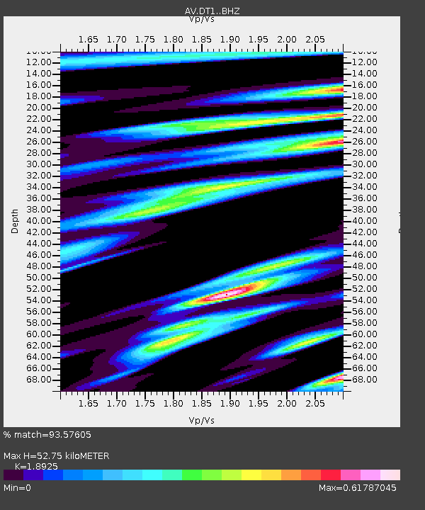
| Estimated Moho Depth: |
52.75 km |
| Estimated Crust Vp/Vs: |
1.89 |
| Assumed Crust Vp: |
5.989 km/s |
| Estimated Crust Vs: |
3.165 km/s |
| Estimated Crust Poisson's Ratio: |
0.31 |
|
| Radial Match: |
93.57605 % |
| Radial Bump: |
400 |
| Transverse Match: |
88.24421 % |
| Transverse Bump: |
400 |
| SOD ConfigId: |
26694651 |
| Insert Time: |
2021-12-12 10:59:31.196 +0000 |
| GWidth: |
2.5 |
| Max Bumps: |
400 |
| Tol: |
0.001 |
|

Signal To Noise
| Channel | StoN | STA | LTA |
| AV:DT1: :BHZ:20211128T11:04:36.400024Z | 6.737553 | 2.058873E-6 | 3.0558172E-7 |
| AV:DT1: :BHN:20211128T11:04:36.400024Z | 2.4583948 | 4.437722E-7 | 1.80513E-7 |
| AV:DT1: :BHE:20211128T11:04:36.400024Z | 2.5575755 | 5.633535E-7 | 2.2026859E-7 |
| Arrivals |
| Ps | 8.0 SECOND |
| PpPs | 25 SECOND |
| PsPs/PpSs | 33 SECOND |


