You are here: Home > Network List > AV - Alaska Volcano Observatory Stations List
> Station KAVE Katnai Ventifact, Alaska > Earthquake Result Viewer
KAVE Katnai Ventifact, Alaska - Earthquake Result Viewer
| Earthquake location: |
Northern Peru |
| Earthquake latitude/longitude: |
-4.5/-76.7 |
| Earthquake time(UTC): |
2021/11/28 (332) 10:52:14 GMT |
| Earthquake Depth: |
99 km |
| Earthquake Magnitude: |
7.4 Mi |
| Earthquake Catalog/Contributor: |
NEIC PDE/at |
|
| Network: |
AV Alaska Volcano Observatory |
| Station: |
KAVE Katnai Ventifact, Alaska |
| Lat/Lon: |
58.20 N/155.02 W |
| Elevation: |
702 m |
|
| Distance: |
87.7 deg |
| Az: |
328.734 deg |
| Baz: |
102.275 deg |
| Ray Param: |
0.042955775 |
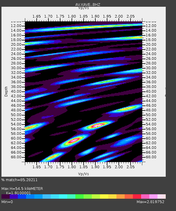
| Estimated Moho Depth: |
54.5 km |
| Estimated Crust Vp/Vs: |
1.91 |
| Assumed Crust Vp: |
6.438 km/s |
| Estimated Crust Vs: |
3.371 km/s |
| Estimated Crust Poisson's Ratio: |
0.31 |
|
| Radial Match: |
85.28211 % |
| Radial Bump: |
400 |
| Transverse Match: |
85.36121 % |
| Transverse Bump: |
400 |
| SOD ConfigId: |
26694651 |
| Insert Time: |
2021-12-12 10:59:49.862 +0000 |
| GWidth: |
2.5 |
| Max Bumps: |
400 |
| Tol: |
0.001 |
|
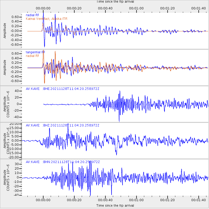
Signal To Noise
| Channel | StoN | STA | LTA |
| AV:KAVE: :BHZ:20211128T11:04:20.258972Z | 14.010483 | 5.320442E-6 | 3.7974726E-7 |
| AV:KAVE: :BHN:20211128T11:04:20.258972Z | 3.320295 | 1.7353848E-6 | 5.226598E-7 |
| AV:KAVE: :BHE:20211128T11:04:20.258972Z | 11.036538 | 6.853755E-6 | 6.210059E-7 |
| Arrivals |
| Ps | 7.9 SECOND |
| PpPs | 24 SECOND |
| PsPs/PpSs | 32 SECOND |


