You are here: Home > Network List > AZ - ANZA Regional Network Stations List
> Station PFO AZ.PFO > Earthquake Result Viewer
PFO AZ.PFO - Earthquake Result Viewer
| Earthquake location: |
Northern Peru |
| Earthquake latitude/longitude: |
-4.5/-76.7 |
| Earthquake time(UTC): |
2021/11/28 (332) 10:52:14 GMT |
| Earthquake Depth: |
99 km |
| Earthquake Magnitude: |
7.4 Mi |
| Earthquake Catalog/Contributor: |
NEIC PDE/at |
|
| Network: |
AZ ANZA Regional Network |
| Station: |
PFO AZ.PFO |
| Lat/Lon: |
33.61 N/116.46 W |
| Elevation: |
1259 m |
|
| Distance: |
53.4 deg |
| Az: |
318.313 deg |
| Baz: |
127.39 deg |
| Ray Param: |
0.06583549 |
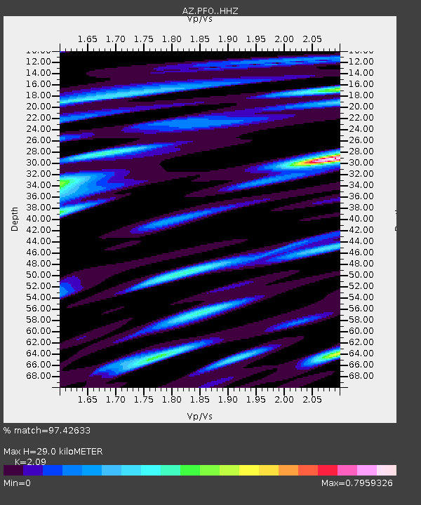
| Estimated Moho Depth: |
29.0 km |
| Estimated Crust Vp/Vs: |
2.09 |
| Assumed Crust Vp: |
6.264 km/s |
| Estimated Crust Vs: |
2.997 km/s |
| Estimated Crust Poisson's Ratio: |
0.35 |
|
| Radial Match: |
97.42633 % |
| Radial Bump: |
313 |
| Transverse Match: |
90.699936 % |
| Transverse Bump: |
400 |
| SOD ConfigId: |
26694651 |
| Insert Time: |
2021-12-12 11:01:33.468 +0000 |
| GWidth: |
2.5 |
| Max Bumps: |
400 |
| Tol: |
0.001 |
|

Signal To Noise
| Channel | StoN | STA | LTA |
| AZ:PFO: :HHZ:20211128T11:00:52.718018Z | 14.897641 | 3.7996408E-6 | 2.5504983E-7 |
| AZ:PFO: :HHN:20211128T11:00:52.718018Z | 8.302309 | 1.3480355E-6 | 1.6236876E-7 |
| AZ:PFO: :HHE:20211128T11:00:52.718018Z | 6.5050735 | 1.8767352E-6 | 2.885033E-7 |
| Arrivals |
| Ps | 5.3 SECOND |
| PpPs | 14 SECOND |
| PsPs/PpSs | 19 SECOND |


