You are here: Home > Network List > C8 - Canadian Seismic Research Network () Stations List
> Station GRIB Gribbell Island, BC, CA > Earthquake Result Viewer
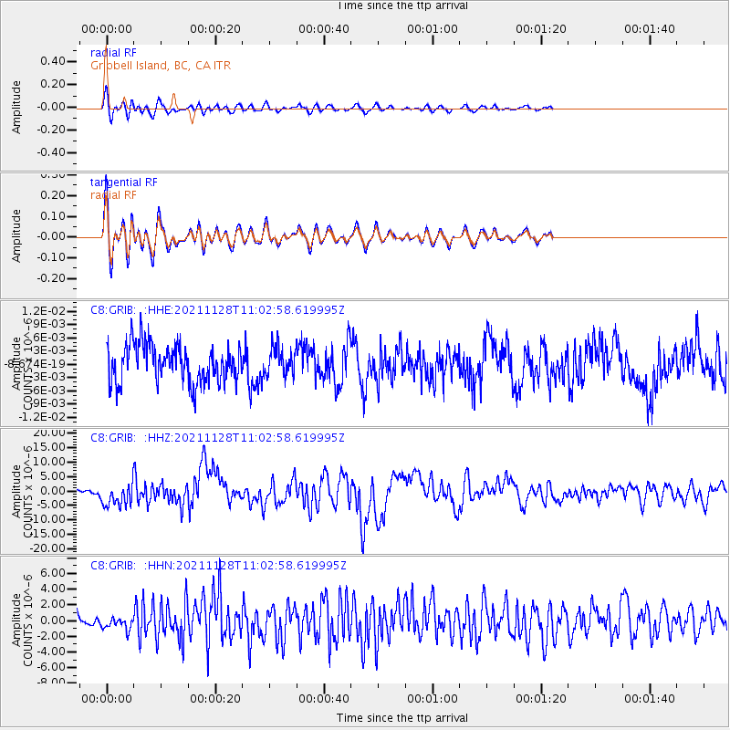
GRIB Gribbell Island, BC, CA - Earthquake Result Viewer
*The percent match for this event was below the threshold and hence no stack was calculated.
| Earthquake location: |
Northern Peru |
| Earthquake latitude/longitude: |
-4.5/-76.7 |
| Earthquake time(UTC): |
2021/11/28 (332) 10:52:14 GMT |
| Earthquake Depth: |
99 km |
| Earthquake Magnitude: |
7.4 Mi |
| Earthquake Catalog/Contributor: |
NEIC PDE/at |
|
| Network: |
C8 Canadian Seismic Research Network () |
| Station: |
GRIB Gribbell Island, BC, CA |
| Lat/Lon: |
53.34 N/129.14 W |
| Elevation: |
418 m |
|
| Distance: |
72.4 deg |
| Az: |
330.089 deg |
| Baz: |
124.002 deg |
| Ray Param: |
$rayparam |
*The percent match for this event was below the threshold and hence was not used in the summary stack. |
|
| Radial Match: |
79.3326 % |
| Radial Bump: |
400 |
| Transverse Match: |
79.32545 % |
| Transverse Bump: |
400 |
| SOD ConfigId: |
26694651 |
| Insert Time: |
2021-12-12 11:03:27.175 +0000 |
| GWidth: |
2.5 |
| Max Bumps: |
400 |
| Tol: |
0.001 |
|
Signal To Noise
| Channel | StoN | STA | LTA |
| C8:GRIB: :HHZ:20211128T11:02:58.619995Z | 8.267093 | 3.9777856E-6 | 4.8115896E-7 |
| C8:GRIB: :HHN:20211128T11:02:58.619995Z | 0.92718 | 8.154741E-7 | 8.795208E-7 |
| C8:GRIB: :HHE:20211128T11:02:58.619995Z | 0.7221687 | 3.0669782E-9 | 4.2469E-9 |
| Arrivals |
| Ps | |
| PpPs | |
| PsPs/PpSs | |


