You are here: Home > Network List > CN - Canadian National Seismograph Network Stations List
> Station GOBB Galiano Island, BC, CA > Earthquake Result Viewer
GOBB Galiano Island, BC, CA - Earthquake Result Viewer
| Earthquake location: |
Northern Peru |
| Earthquake latitude/longitude: |
-4.5/-76.7 |
| Earthquake time(UTC): |
2021/11/28 (332) 10:52:14 GMT |
| Earthquake Depth: |
99 km |
| Earthquake Magnitude: |
7.4 Mi |
| Earthquake Catalog/Contributor: |
NEIC PDE/at |
|
| Network: |
CN Canadian National Seismograph Network |
| Station: |
GOBB Galiano Island, BC, CA |
| Lat/Lon: |
48.95 N/123.51 W |
| Elevation: |
143 m |
|
| Distance: |
67.0 deg |
| Az: |
328.516 deg |
| Baz: |
127.831 deg |
| Ray Param: |
0.057018764 |
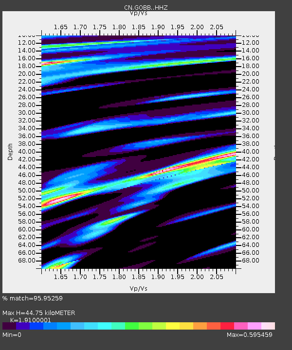
| Estimated Moho Depth: |
44.75 km |
| Estimated Crust Vp/Vs: |
1.91 |
| Assumed Crust Vp: |
6.566 km/s |
| Estimated Crust Vs: |
3.438 km/s |
| Estimated Crust Poisson's Ratio: |
0.31 |
|
| Radial Match: |
95.95259 % |
| Radial Bump: |
393 |
| Transverse Match: |
84.62496 % |
| Transverse Bump: |
400 |
| SOD ConfigId: |
26694651 |
| Insert Time: |
2021-12-12 11:08:38.190 +0000 |
| GWidth: |
2.5 |
| Max Bumps: |
400 |
| Tol: |
0.001 |
|

Signal To Noise
| Channel | StoN | STA | LTA |
| CN:GOBB: :HHZ:20211128T11:02:25.289978Z | 7.6651034 | 5.740118E-6 | 7.488637E-7 |
| CN:GOBB: :HHN:20211128T11:02:25.289978Z | 2.6998966 | 2.2272418E-6 | 8.2493597E-7 |
| CN:GOBB: :HHE:20211128T11:02:25.289978Z | 2.8039718 | 1.6989788E-6 | 6.059187E-7 |
| Arrivals |
| Ps | 6.4 SECOND |
| PpPs | 19 SECOND |
| PsPs/PpSs | 26 SECOND |


