You are here: Home > Network List > CN - Canadian National Seismograph Network Stations List
> Station INK INUVIK, NT > Earthquake Result Viewer
INK INUVIK, NT - Earthquake Result Viewer
| Earthquake location: |
Northern Peru |
| Earthquake latitude/longitude: |
-4.5/-76.7 |
| Earthquake time(UTC): |
2021/11/28 (332) 10:52:14 GMT |
| Earthquake Depth: |
99 km |
| Earthquake Magnitude: |
7.4 Mi |
| Earthquake Catalog/Contributor: |
NEIC PDE/at |
|
| Network: |
CN Canadian National Seismograph Network |
| Station: |
INK INUVIK, NT |
| Lat/Lon: |
68.31 N/133.53 W |
| Elevation: |
44 m |
|
| Distance: |
82.5 deg |
| Az: |
341.707 deg |
| Baz: |
122.685 deg |
| Ray Param: |
0.046634275 |
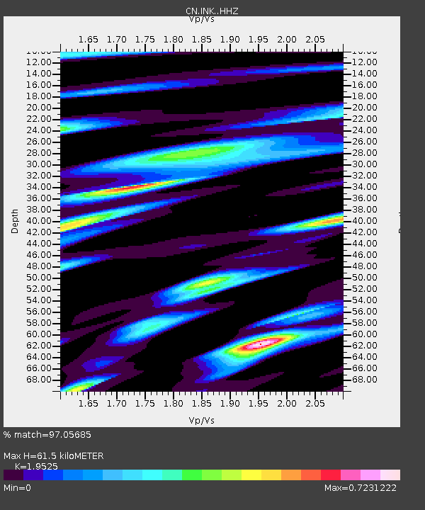
| Estimated Moho Depth: |
61.5 km |
| Estimated Crust Vp/Vs: |
1.95 |
| Assumed Crust Vp: |
6.171 km/s |
| Estimated Crust Vs: |
3.161 km/s |
| Estimated Crust Poisson's Ratio: |
0.32 |
|
| Radial Match: |
97.05685 % |
| Radial Bump: |
323 |
| Transverse Match: |
86.513565 % |
| Transverse Bump: |
400 |
| SOD ConfigId: |
26694651 |
| Insert Time: |
2021-12-12 11:08:56.860 +0000 |
| GWidth: |
2.5 |
| Max Bumps: |
400 |
| Tol: |
0.001 |
|
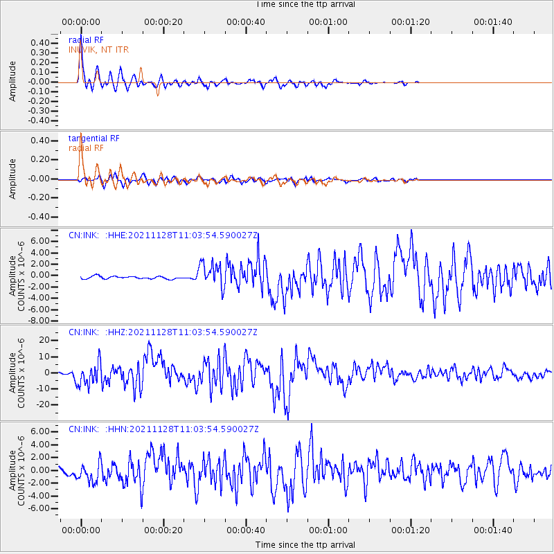
Signal To Noise
| Channel | StoN | STA | LTA |
| CN:INK: :HHZ:20211128T11:03:54.590027Z | 15.743076 | 7.1209874E-6 | 4.52325E-7 |
| CN:INK: :HHN:20211128T11:03:54.590027Z | 3.5035822 | 1.5469027E-6 | 4.415203E-7 |
| CN:INK: :HHE:20211128T11:03:54.590027Z | 9.493293 | 2.1555743E-6 | 2.2706287E-7 |
| Arrivals |
| Ps | 9.7 SECOND |
| PpPs | 29 SECOND |
| PsPs/PpSs | 38 SECOND |


