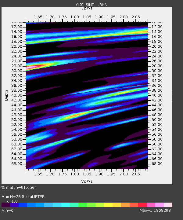
SIND YL.SIND - Earthquake Result Viewer
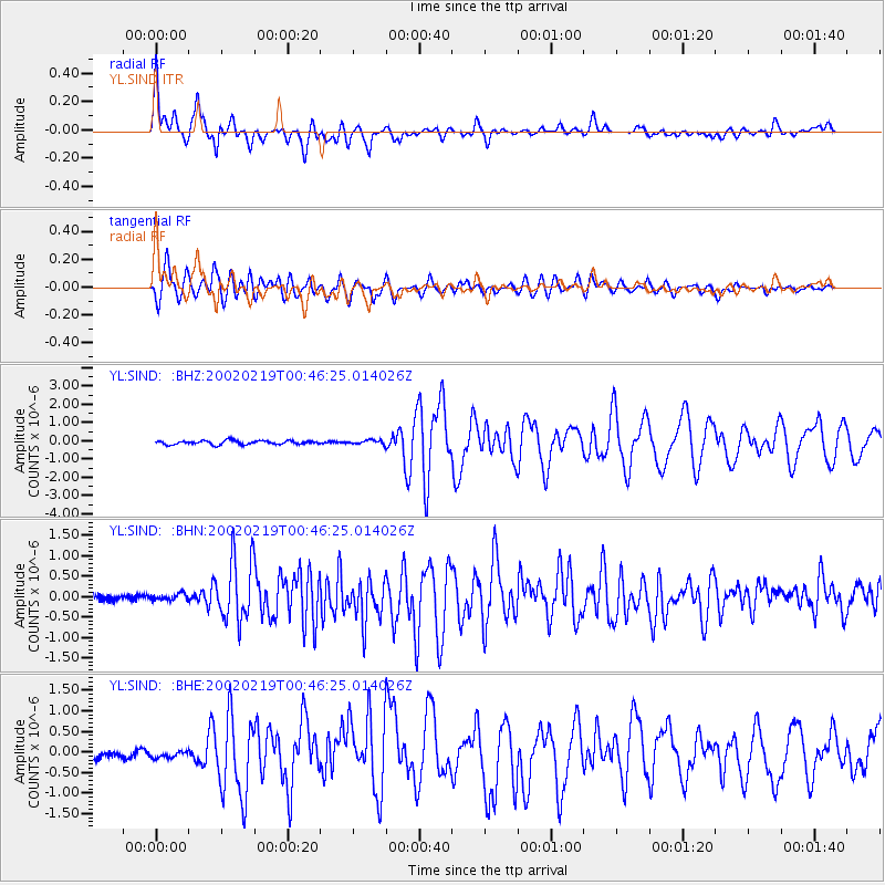
Earthquake location: New Ireland Region, P.N.G.
Earthquake latitude/longitude: -3.7/151.0
Earthquake time(UTC): 2002/02/19 (050) 00:35:45 GMT
Earthquake Depth: 10 km
Earthquake Magnitude: 5.9 MB, 6.0 MS, 6.1 MW, 6.1 MW
Earthquake Catalog/Contributor: WHDF/NEIC
Network: YL Himalayan Nepal Tibet Experiment
Station: SIND YL.SIND
Lat/Lon: 27.21 N/85.91 E
Elevation: 465 m
Distance: 69.8 deg
Az: 300.625 deg
Baz: 105.371 deg
Ray Param: 0.05539473
Estimated Moho Depth: 28.5 km
Estimated Crust Vp/Vs: 1.60
Assumed Crust Vp: 6.142 km/s
Estimated Crust Vs: 3.839 km/s
Estimated Crust Poisson's Ratio: 0.18
Radial Match: 91.0564 %
Radial Bump: 400
Transverse Match: 88.89311 %
Transverse Bump: 400
SOD ConfigId: 16820
Insert Time: 2010-02-26 16:11:34.200 +0000
GWidth: 2.5
Max Bumps: 400
Tol: 0.001

Signal To Noise

ChannelStoNSTALTA
YL:SIND: :BHN:20020219T00:46:25.014026Z0.71066249.622069E-81.3539578E-7
YL:SIND: :BHE:20020219T00:46:25.014026Z0.62533717.9927545E-81.2781514E-7
YL:SIND: :BHZ:20020219T00:46:25.014026Z1.09396831.13287285E-71.0355628E-7
Arrivals
Ps2.9 SECOND
PpPs12 SECOND
PsPs/PpSs15 SECOND