You are here: Home > Network List > CN - Canadian National Seismograph Network Stations List
> Station TAHB Tahsis, BC, CA > Earthquake Result Viewer
TAHB Tahsis, BC, CA - Earthquake Result Viewer
| Earthquake location: |
Northern Peru |
| Earthquake latitude/longitude: |
-4.5/-76.7 |
| Earthquake time(UTC): |
2021/11/28 (332) 10:52:14 GMT |
| Earthquake Depth: |
99 km |
| Earthquake Magnitude: |
7.4 Mi |
| Earthquake Catalog/Contributor: |
NEIC PDE/at |
|
| Network: |
CN Canadian National Seismograph Network |
| Station: |
TAHB Tahsis, BC, CA |
| Lat/Lon: |
49.89 N/126.68 W |
| Elevation: |
455 m |
|
| Distance: |
69.2 deg |
| Az: |
328.006 deg |
| Baz: |
125.242 deg |
| Ray Param: |
0.05555916 |
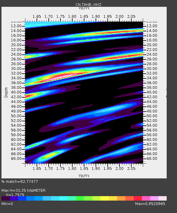
| Estimated Moho Depth: |
33.25 km |
| Estimated Crust Vp/Vs: |
1.76 |
| Assumed Crust Vp: |
6.24 km/s |
| Estimated Crust Vs: |
3.55 km/s |
| Estimated Crust Poisson's Ratio: |
0.26 |
|
| Radial Match: |
92.77477 % |
| Radial Bump: |
400 |
| Transverse Match: |
77.24264 % |
| Transverse Bump: |
400 |
| SOD ConfigId: |
26694651 |
| Insert Time: |
2021-12-12 11:10:09.873 +0000 |
| GWidth: |
2.5 |
| Max Bumps: |
400 |
| Tol: |
0.001 |
|

Signal To Noise
| Channel | StoN | STA | LTA |
| CN:TAHB: :HHZ:20211128T11:02:39.150024Z | 7.8487334 | 4.0469354E-6 | 5.1561636E-7 |
| CN:TAHB: :HHN:20211128T11:02:39.150024Z | 3.3109674 | 1.2944665E-6 | 3.9096324E-7 |
| CN:TAHB: :HHE:20211128T11:02:39.150024Z | 4.155808 | 1.5530197E-6 | 3.7369864E-7 |
| Arrivals |
| Ps | 4.2 SECOND |
| PpPs | 14 SECOND |
| PsPs/PpSs | 18 SECOND |


