You are here: Home > Network List > CN - Canadian National Seismograph Network Stations List
> Station TXDB Texada, BC, CA > Earthquake Result Viewer
TXDB Texada, BC, CA - Earthquake Result Viewer
| Earthquake location: |
Northern Peru |
| Earthquake latitude/longitude: |
-4.5/-76.7 |
| Earthquake time(UTC): |
2021/11/28 (332) 10:52:14 GMT |
| Earthquake Depth: |
99 km |
| Earthquake Magnitude: |
7.4 Mi |
| Earthquake Catalog/Contributor: |
NEIC PDE/at |
|
| Network: |
CN Canadian National Seismograph Network |
| Station: |
TXDB Texada, BC, CA |
| Lat/Lon: |
49.70 N/124.44 W |
| Elevation: |
501 m |
|
| Distance: |
67.9 deg |
| Az: |
328.759 deg |
| Baz: |
127.223 deg |
| Ray Param: |
0.05640079 |
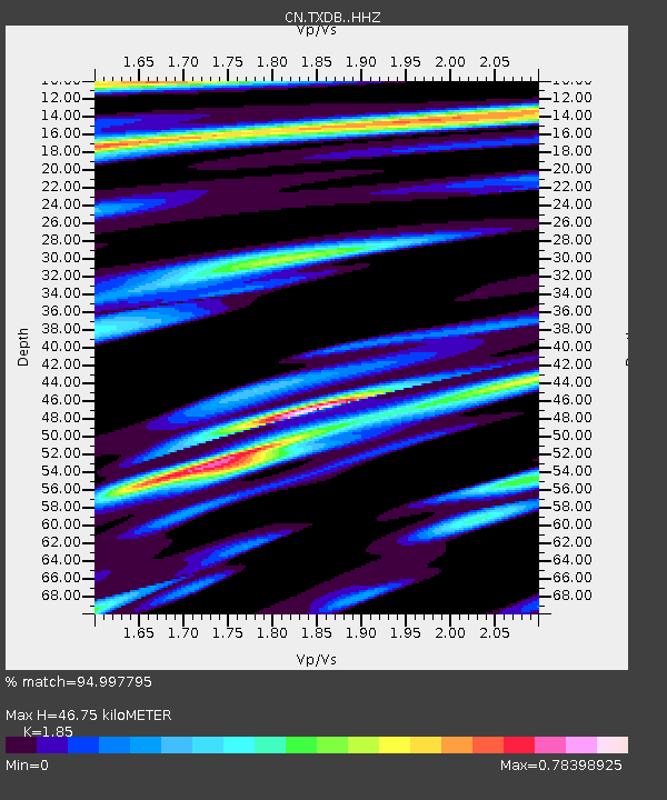
| Estimated Moho Depth: |
46.75 km |
| Estimated Crust Vp/Vs: |
1.85 |
| Assumed Crust Vp: |
6.391 km/s |
| Estimated Crust Vs: |
3.454 km/s |
| Estimated Crust Poisson's Ratio: |
0.29 |
|
| Radial Match: |
94.997795 % |
| Radial Bump: |
380 |
| Transverse Match: |
85.4198 % |
| Transverse Bump: |
400 |
| SOD ConfigId: |
26694651 |
| Insert Time: |
2021-12-12 11:10:15.991 +0000 |
| GWidth: |
2.5 |
| Max Bumps: |
400 |
| Tol: |
0.001 |
|

Signal To Noise
| Channel | StoN | STA | LTA |
| CN:TXDB: :HHZ:20211128T11:02:31.179993Z | 13.627244 | 5.191484E-6 | 3.8096363E-7 |
| CN:TXDB: :HHN:20211128T11:02:31.179993Z | 3.1346042 | 1.780635E-6 | 5.680574E-7 |
| CN:TXDB: :HHE:20211128T11:02:31.179993Z | 6.5457644 | 2.0897464E-6 | 3.192517E-7 |
| Arrivals |
| Ps | 6.5 SECOND |
| PpPs | 20 SECOND |
| PsPs/PpSs | 27 SECOND |


