You are here: Home > Network List > CN - Canadian National Seismograph Network Stations List
> Station ULM LAC DU BONNET, MB > Earthquake Result Viewer
ULM LAC DU BONNET, MB - Earthquake Result Viewer
| Earthquake location: |
Northern Peru |
| Earthquake latitude/longitude: |
-4.5/-76.7 |
| Earthquake time(UTC): |
2021/11/28 (332) 10:52:14 GMT |
| Earthquake Depth: |
99 km |
| Earthquake Magnitude: |
7.4 Mi |
| Earthquake Catalog/Contributor: |
NEIC PDE/at |
|
| Network: |
CN Canadian National Seismograph Network |
| Station: |
ULM LAC DU BONNET, MB |
| Lat/Lon: |
50.25 N/95.88 W |
| Elevation: |
251 m |
|
| Distance: |
57.0 deg |
| Az: |
345.437 deg |
| Baz: |
157.016 deg |
| Ray Param: |
0.06349745 |
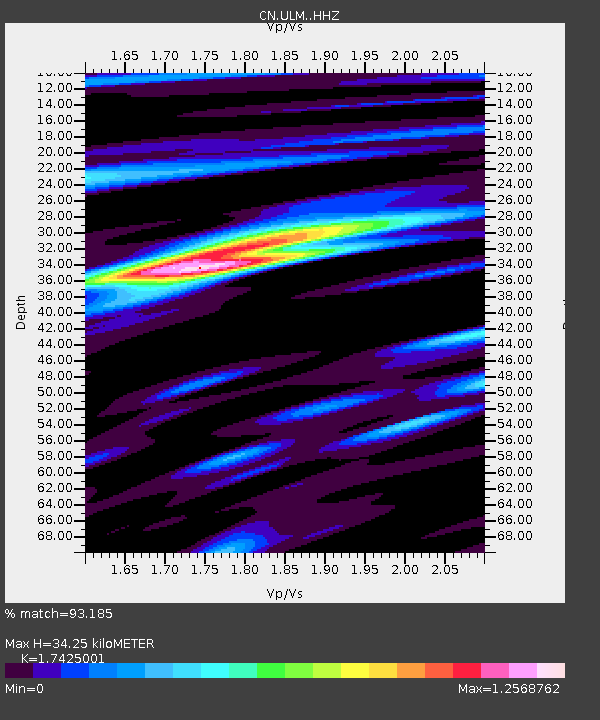
| Estimated Moho Depth: |
34.25 km |
| Estimated Crust Vp/Vs: |
1.74 |
| Assumed Crust Vp: |
6.459 km/s |
| Estimated Crust Vs: |
3.707 km/s |
| Estimated Crust Poisson's Ratio: |
0.25 |
|
| Radial Match: |
93.185 % |
| Radial Bump: |
375 |
| Transverse Match: |
74.72358 % |
| Transverse Bump: |
400 |
| SOD ConfigId: |
26694651 |
| Insert Time: |
2021-12-12 11:10:16.711 +0000 |
| GWidth: |
2.5 |
| Max Bumps: |
400 |
| Tol: |
0.001 |
|
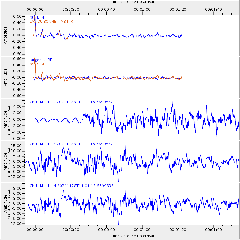
Signal To Noise
| Channel | StoN | STA | LTA |
| CN:ULM: :HHZ:20211128T11:01:18.669983Z | 6.18558 | 5.5708356E-6 | 9.0061656E-7 |
| CN:ULM: :HHN:20211128T11:01:18.669983Z | 3.9913337 | 2.3972175E-6 | 6.0060563E-7 |
| CN:ULM: :HHE:20211128T11:01:18.669983Z | 3.0171385 | 1.382208E-6 | 4.5811882E-7 |
| Arrivals |
| Ps | 4.1 SECOND |
| PpPs | 14 SECOND |
| PsPs/PpSs | 18 SECOND |


