You are here: Home > Network List > CN - Canadian National Seismograph Network Stations List
> Station WPB Watts Point, BC, CA > Earthquake Result Viewer
WPB Watts Point, BC, CA - Earthquake Result Viewer
| Earthquake location: |
Northern Peru |
| Earthquake latitude/longitude: |
-4.5/-76.7 |
| Earthquake time(UTC): |
2021/11/28 (332) 10:52:14 GMT |
| Earthquake Depth: |
99 km |
| Earthquake Magnitude: |
7.4 Mi |
| Earthquake Catalog/Contributor: |
NEIC PDE/at |
|
| Network: |
CN Canadian National Seismograph Network |
| Station: |
WPB Watts Point, BC, CA |
| Lat/Lon: |
49.65 N/123.21 W |
| Elevation: |
260 m |
|
| Distance: |
67.2 deg |
| Az: |
329.245 deg |
| Baz: |
128.342 deg |
| Ray Param: |
0.05683986 |
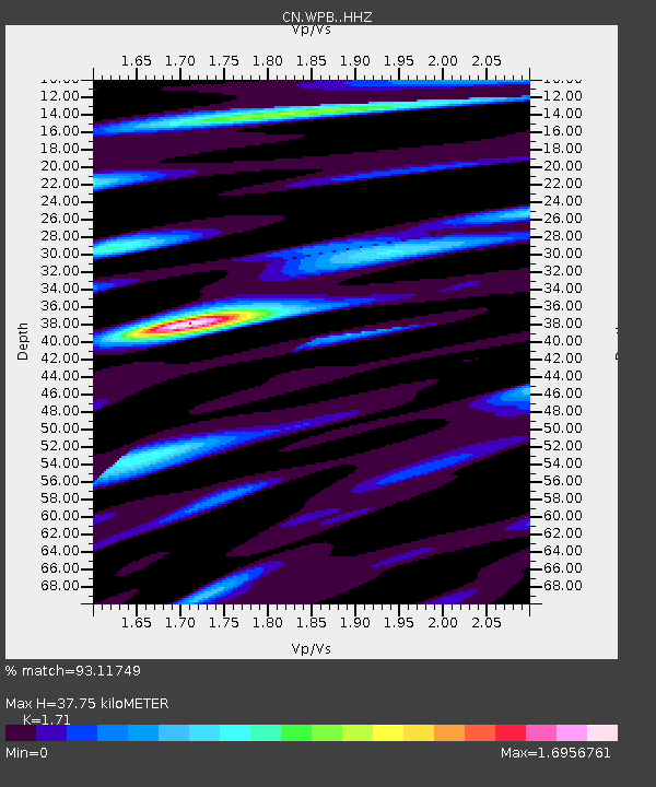
| Estimated Moho Depth: |
37.75 km |
| Estimated Crust Vp/Vs: |
1.71 |
| Assumed Crust Vp: |
6.566 km/s |
| Estimated Crust Vs: |
3.84 km/s |
| Estimated Crust Poisson's Ratio: |
0.24 |
|
| Radial Match: |
93.11749 % |
| Radial Bump: |
400 |
| Transverse Match: |
83.788216 % |
| Transverse Bump: |
400 |
| SOD ConfigId: |
26694651 |
| Insert Time: |
2021-12-12 11:10:28.619 +0000 |
| GWidth: |
2.5 |
| Max Bumps: |
400 |
| Tol: |
0.001 |
|

Signal To Noise
| Channel | StoN | STA | LTA |
| CN:WPB: :HHZ:20211128T11:02:27.030029Z | 16.87854 | 5.359669E-6 | 3.175434E-7 |
| CN:WPB: :HHN:20211128T11:02:27.030029Z | 5.210341 | 1.6536054E-6 | 3.173699E-7 |
| CN:WPB: :HHE:20211128T11:02:27.030029Z | 8.419745 | 2.444257E-6 | 2.9030056E-7 |
| Arrivals |
| Ps | 4.3 SECOND |
| PpPs | 15 SECOND |
| PsPs/PpSs | 19 SECOND |


