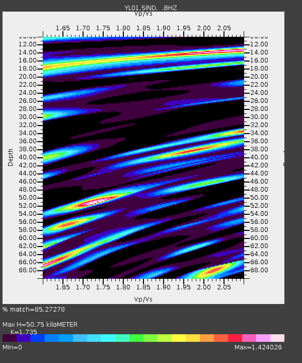
SIND YL.SIND - Earthquake Result Viewer
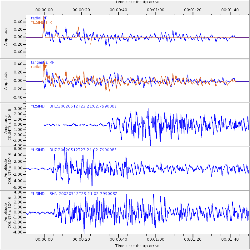
Earthquake location: Halmahera, Indonesia
Earthquake latitude/longitude: -1.1/127.1
Earthquake time(UTC): 2002/05/12 (132) 23:12:52 GMT
Earthquake Depth: 33 km
Earthquake Magnitude: 5.7 MB, 5.6 MS, 5.9 MW, 5.7 MW
Earthquake Catalog/Contributor: WHDF/NEIC
Network: YL Himalayan Nepal Tibet Experiment
Station: SIND YL.SIND
Lat/Lon: 27.21 N/85.91 E
Elevation: 465 m
Distance: 48.6 deg
Az: 308.597 deg
Baz: 118.668 deg
Ray Param: 0.06917998
Estimated Moho Depth: 50.75 km
Estimated Crust Vp/Vs: 1.74
Assumed Crust Vp: 6.142 km/s
Estimated Crust Vs: 3.54 km/s
Estimated Crust Poisson's Ratio: 0.25
Radial Match: 85.27278 %
Radial Bump: 400
Transverse Match: 83.473145 %
Transverse Bump: 400
SOD ConfigId: 16844
Insert Time: 2010-02-26 16:11:35.483 +0000
GWidth: 2.5
Max Bumps: 400
Tol: 0.001

Signal To Noise

ChannelStoNSTALTA
YL:SIND: :BHZ:20020512T23:21:02.799008Z3.68944054.07739E-71.1051513E-7
YL:SIND: :BHN:20020512T23:21:02.799008Z1.12100631.0507739E-79.373489E-8
YL:SIND: :BHE:20020512T23:21:02.799008Z2.58412622.1119327E-78.172715E-8
Arrivals
Ps6.4 SECOND
PpPs21 SECOND
PsPs/PpSs28 SECOND