You are here: Home > Network List > CN - Canadian National Seismograph Network Stations List
> Station PAULN Paulatuk, NT, CA > Earthquake Result Viewer
PAULN Paulatuk, NT, CA - Earthquake Result Viewer
| Earthquake location: |
Northern Peru |
| Earthquake latitude/longitude: |
-4.5/-76.7 |
| Earthquake time(UTC): |
2021/11/28 (332) 10:52:14 GMT |
| Earthquake Depth: |
99 km |
| Earthquake Magnitude: |
7.4 Mi |
| Earthquake Catalog/Contributor: |
NEIC PDE/at |
|
| Network: |
CN Canadian National Seismograph Network |
| Station: |
PAULN Paulatuk, NT, CA |
| Lat/Lon: |
69.35 N/124.07 W |
| Elevation: |
10 m |
|
| Distance: |
80.4 deg |
| Az: |
344.649 deg |
| Baz: |
131.934 deg |
| Ray Param: |
0.048084527 |
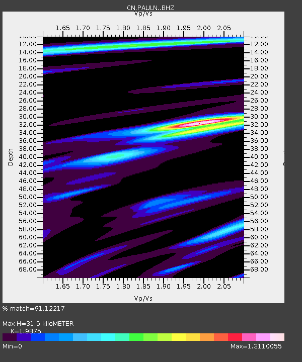
| Estimated Moho Depth: |
31.5 km |
| Estimated Crust Vp/Vs: |
1.99 |
| Assumed Crust Vp: |
6.459 km/s |
| Estimated Crust Vs: |
3.25 km/s |
| Estimated Crust Poisson's Ratio: |
0.33 |
|
| Radial Match: |
91.12217 % |
| Radial Bump: |
400 |
| Transverse Match: |
65.77277 % |
| Transverse Bump: |
400 |
| SOD ConfigId: |
26694651 |
| Insert Time: |
2021-12-12 11:10:44.198 +0000 |
| GWidth: |
2.5 |
| Max Bumps: |
400 |
| Tol: |
0.001 |
|

Signal To Noise
| Channel | StoN | STA | LTA |
| CN:PAULN: :BHZ:20211128T11:03:43.575012Z | 4.6205816 | 3.4481404E-6 | 7.462567E-7 |
| CN:PAULN: :BHN:20211128T11:03:43.575012Z | 1.9364636 | 9.2859256E-7 | 4.7953006E-7 |
| CN:PAULN: :BHE:20211128T11:03:43.575012Z | 1.6920187 | 8.064159E-7 | 4.765999E-7 |
| Arrivals |
| Ps | 4.9 SECOND |
| PpPs | 14 SECOND |
| PsPs/PpSs | 19 SECOND |


