You are here: Home > Network List > CO - South Carolina Seismic Network Stations List
> Station TEEBA Mateeba, Summerville SC > Earthquake Result Viewer
TEEBA Mateeba, Summerville SC - Earthquake Result Viewer
| Earthquake location: |
Northern Peru |
| Earthquake latitude/longitude: |
-4.5/-76.7 |
| Earthquake time(UTC): |
2021/11/28 (332) 10:52:14 GMT |
| Earthquake Depth: |
99 km |
| Earthquake Magnitude: |
7.4 Mi |
| Earthquake Catalog/Contributor: |
NEIC PDE/at |
|
| Network: |
CO South Carolina Seismic Network |
| Station: |
TEEBA Mateeba, Summerville SC |
| Lat/Lon: |
32.90 N/80.19 W |
| Elevation: |
11 m |
|
| Distance: |
37.3 deg |
| Az: |
355.155 deg |
| Baz: |
174.256 deg |
| Ray Param: |
0.075865746 |
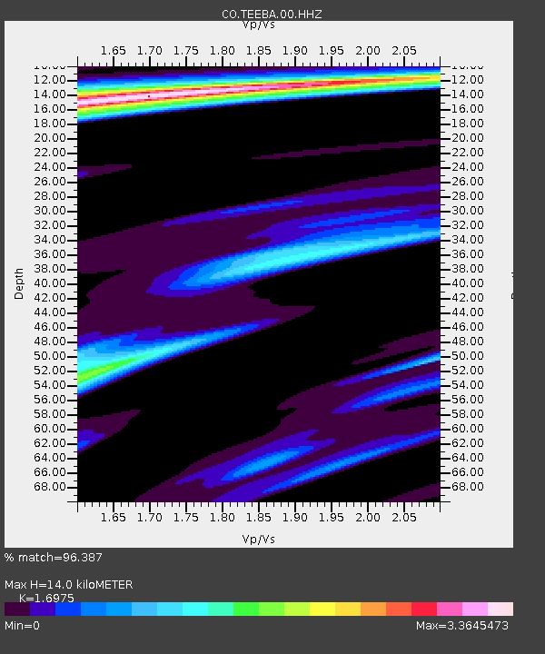
| Estimated Moho Depth: |
14.0 km |
| Estimated Crust Vp/Vs: |
1.70 |
| Assumed Crust Vp: |
6.565 km/s |
| Estimated Crust Vs: |
3.867 km/s |
| Estimated Crust Poisson's Ratio: |
0.23 |
|
| Radial Match: |
96.387 % |
| Radial Bump: |
298 |
| Transverse Match: |
78.76888 % |
| Transverse Bump: |
400 |
| SOD ConfigId: |
26694651 |
| Insert Time: |
2021-12-12 11:10:58.563 +0000 |
| GWidth: |
2.5 |
| Max Bumps: |
400 |
| Tol: |
0.001 |
|

Signal To Noise
| Channel | StoN | STA | LTA |
| CO:TEEBA:00:HHZ:20211128T10:58:46.477997Z | 16.98053 | 8.080177E-6 | 4.7584953E-7 |
| CO:TEEBA:00:HH1:20211128T10:58:46.477997Z | 6.807103 | 5.417179E-6 | 7.958127E-7 |
| CO:TEEBA:00:HH2:20211128T10:58:46.477997Z | 3.9960425 | 3.505438E-6 | 8.772274E-7 |
| Arrivals |
| Ps | 1.6 SECOND |
| PpPs | 5.3 SECOND |
| PsPs/PpSs | 6.9 SECOND |


