You are here: Home > Network List > EI - Irish National Seismic Network (INSN) Stations List
> Station ILTH Corrakit Louth > Earthquake Result Viewer
ILTH Corrakit Louth - Earthquake Result Viewer
| Earthquake location: |
Northern Peru |
| Earthquake latitude/longitude: |
-4.5/-76.7 |
| Earthquake time(UTC): |
2021/11/28 (332) 10:52:14 GMT |
| Earthquake Depth: |
99 km |
| Earthquake Magnitude: |
7.4 Mi |
| Earthquake Catalog/Contributor: |
NEIC PDE/at |
|
| Network: |
EI Irish National Seismic Network (INSN) |
| Station: |
ILTH Corrakit Louth |
| Lat/Lon: |
54.06 N/6.27 W |
| Elevation: |
227 m |
|
| Distance: |
82.3 deg |
| Az: |
34.097 deg |
| Baz: |
251.429 deg |
| Ray Param: |
0.046770003 |
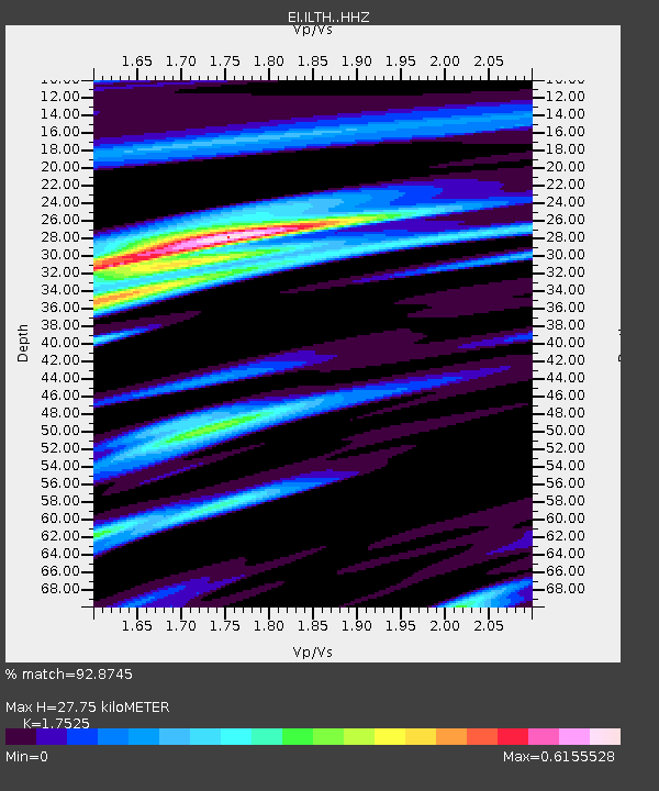
| Estimated Moho Depth: |
27.75 km |
| Estimated Crust Vp/Vs: |
1.75 |
| Assumed Crust Vp: |
6.276 km/s |
| Estimated Crust Vs: |
3.581 km/s |
| Estimated Crust Poisson's Ratio: |
0.26 |
|
| Radial Match: |
92.8745 % |
| Radial Bump: |
370 |
| Transverse Match: |
73.273964 % |
| Transverse Bump: |
400 |
| SOD ConfigId: |
26694651 |
| Insert Time: |
2021-12-12 11:11:19.058 +0000 |
| GWidth: |
2.5 |
| Max Bumps: |
400 |
| Tol: |
0.001 |
|

Signal To Noise
| Channel | StoN | STA | LTA |
| EI:ILTH: :HHZ:20211128T11:03:53.570007Z | 9.698241 | 6.2165022E-6 | 6.409927E-7 |
| EI:ILTH: :HHN:20211128T11:03:53.570007Z | 1.8522246 | 6.8839233E-7 | 3.7165708E-7 |
| EI:ILTH: :HHE:20211128T11:03:53.570007Z | 3.6703703 | 1.764567E-6 | 4.807599E-7 |
| Arrivals |
| Ps | 3.4 SECOND |
| PpPs | 12 SECOND |
| PsPs/PpSs | 15 SECOND |


