You are here: Home > Network List > G - GEOSCOPE Stations List
> Station TAOE Taiohae, Marquises islands > Earthquake Result Viewer
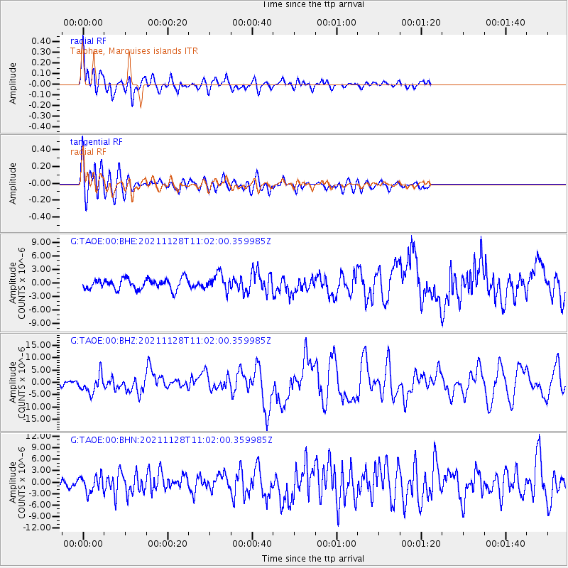
TAOE Taiohae, Marquises islands - Earthquake Result Viewer
*The percent match for this event was below the threshold and hence no stack was calculated.
| Earthquake location: |
Northern Peru |
| Earthquake latitude/longitude: |
-4.5/-76.7 |
| Earthquake time(UTC): |
2021/11/28 (332) 10:52:14 GMT |
| Earthquake Depth: |
99 km |
| Earthquake Magnitude: |
7.4 Mi |
| Earthquake Catalog/Contributor: |
NEIC PDE/at |
|
| Network: |
G GEOSCOPE |
| Station: |
TAOE Taiohae, Marquises islands |
| Lat/Lon: |
8.85 S/140.15 W |
| Elevation: |
800 m |
|
| Distance: |
63.1 deg |
| Az: |
262.395 deg |
| Baz: |
90.57 deg |
| Ray Param: |
$rayparam |
*The percent match for this event was below the threshold and hence was not used in the summary stack. |
|
| Radial Match: |
83.10941 % |
| Radial Bump: |
400 |
| Transverse Match: |
77.35888 % |
| Transverse Bump: |
400 |
| SOD ConfigId: |
26694651 |
| Insert Time: |
2021-12-12 11:11:49.425 +0000 |
| GWidth: |
2.5 |
| Max Bumps: |
400 |
| Tol: |
0.001 |
|
Signal To Noise
| Channel | StoN | STA | LTA |
| G:TAOE:00:BHZ:20211128T11:02:00.359985Z | 3.1308968 | 3.750579E-6 | 1.1979249E-6 |
| G:TAOE:00:BHN:20211128T11:02:00.359985Z | 1.6785 | 2.1613723E-6 | 1.2876808E-6 |
| G:TAOE:00:BHE:20211128T11:02:00.359985Z | 1.5860153 | 1.8576502E-6 | 1.1712687E-6 |
| Arrivals |
| Ps | |
| PpPs | |
| PsPs/PpSs | |


