You are here: Home > Network List > G - GEOSCOPE Stations List
> Station UNM Unam,Mexico > Earthquake Result Viewer
UNM Unam,Mexico - Earthquake Result Viewer

| Earthquake location: |
Northern Peru |
| Earthquake latitude/longitude: |
-4.5/-76.7 |
| Earthquake time(UTC): |
2021/11/28 (332) 10:52:14 GMT |
| Earthquake Depth: |
99 km |
| Earthquake Magnitude: |
7.4 Mi |
| Earthquake Catalog/Contributor: |
NEIC PDE/at |
|
| Network: |
G GEOSCOPE |
| Station: |
UNM Unam,Mexico |
| Lat/Lon: |
19.33 N/99.18 W |
| Elevation: |
2280 m |
|
| Distance: |
32.4 deg |
| Az: |
317.645 deg |
| Baz: |
134.662 deg |
| Ray Param: |
0.07840435 |
| Estimated Moho Depth: |
35.25 km |
| Estimated Crust Vp/Vs: |
2.10 |
| Assumed Crust Vp: |
6.597 km/s |
| Estimated Crust Vs: |
3.145 km/s |
| Estimated Crust Poisson's Ratio: |
0.35 |
|
| Radial Match: |
93.35616 % |
| Radial Bump: |
400 |
| Transverse Match: |
79.72331 % |
| Transverse Bump: |
400 |
| SOD ConfigId: |
26694651 |
| Insert Time: |
2021-12-12 11:11:50.322 +0000 |
| GWidth: |
2.5 |
| Max Bumps: |
400 |
| Tol: |
0.001 |
|
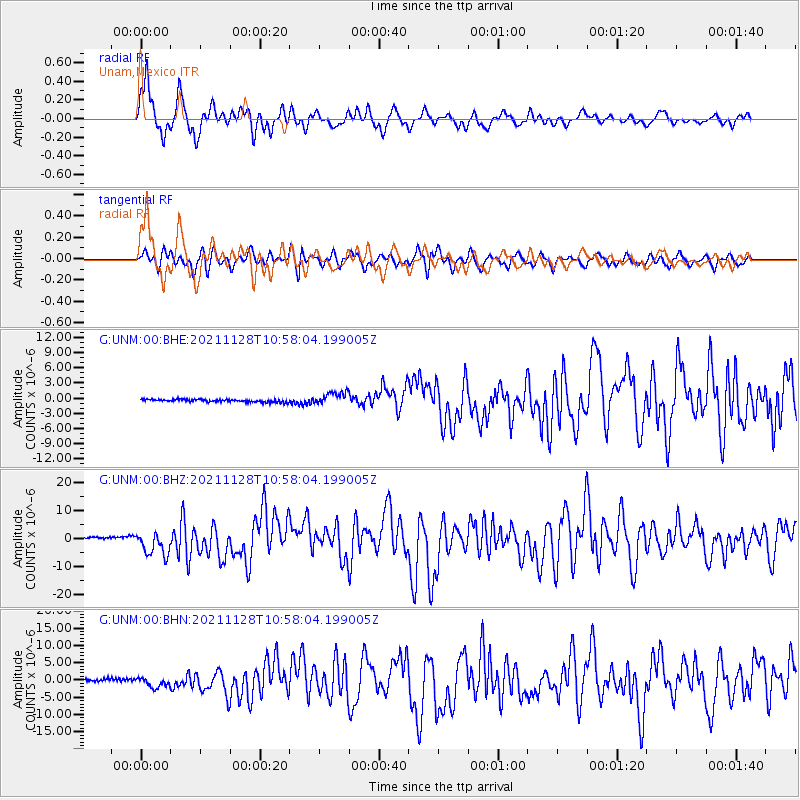
Signal To Noise
| Channel | StoN | STA | LTA |
| G:UNM:00:BHZ:20211128T10:58:04.199005Z | 11.180145 | 4.2350175E-6 | 3.787981E-7 |
| G:UNM:00:BHN:20211128T10:58:04.199005Z | 3.89352 | 1.4679499E-6 | 3.7702384E-7 |
| G:UNM:00:BHE:20211128T10:58:04.199005Z | 4.7922525 | 1.2619481E-6 | 2.633309E-7 |
| Arrivals |
| Ps | 6.3 SECOND |
| PpPs | 15 SECOND |
| PsPs/PpSs | 22 SECOND |


