You are here: Home > Network List > YL01 - Himalayan Nepal Tibet Experiment Stations List
> Station SIND YL.SIND > Earthquake Result Viewer
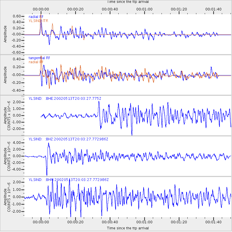
SIND YL.SIND - Earthquake Result Viewer

| Earthquake location: |
Philippine Islands Region |
| Earthquake latitude/longitude: |
19.1/121.2 |
| Earthquake time(UTC): |
2002/05/13 (133) 19:57:22 GMT |
| Earthquake Depth: |
33 km |
| Earthquake Magnitude: |
5.6 MB, 5.3 MS, 5.8 MW |
| Earthquake Catalog/Contributor: |
WHDF/NEIC |
|
| Network: |
YL Himalayan Nepal Tibet Experiment |
| Station: |
SIND YL.SIND |
| Lat/Lon: |
27.21 N/85.91 E |
| Elevation: |
465 m |
|
| Distance: |
33.4 deg |
| Az: |
290.575 deg |
| Baz: |
96.335 deg |
| Ray Param: |
0.07818432 |
| Estimated Moho Depth: |
55.5 km |
| Estimated Crust Vp/Vs: |
1.74 |
| Assumed Crust Vp: |
6.142 km/s |
| Estimated Crust Vs: |
3.535 km/s |
| Estimated Crust Poisson's Ratio: |
0.25 |
|
| Radial Match: |
80.27676 % |
| Radial Bump: |
400 |
| Transverse Match: |
84.1772 % |
| Transverse Bump: |
400 |
| SOD ConfigId: |
16844 |
| Insert Time: |
2010-02-26 16:11:37.195 +0000 |
| GWidth: |
2.5 |
| Max Bumps: |
400 |
| Tol: |
0.001 |
|
Signal To Noise
| Channel | StoN | STA | LTA |
| YL:SIND: :BHZ:20020513T20:03:27.772986Z | 17.46907 | 2.0646687E-6 | 1.1818996E-7 |
| YL:SIND: :BHN:20020513T20:03:27.772986Z | 3.878102 | 5.5661053E-7 | 1.4352653E-7 |
| YL:SIND: :BHE:20020513T20:03:27.775Z | 4.801121 | 8.7490974E-7 | 1.822303E-7 |
| Arrivals |
| Ps | 7.2 SECOND |
| PpPs | 23 SECOND |
| PsPs/PpSs | 30 SECOND |


