You are here: Home > Network List > GB - Great Britain Seismograph Network Stations List
> Station MCH1 MICHAELCHURCH, WALES > Earthquake Result Viewer
MCH1 MICHAELCHURCH, WALES - Earthquake Result Viewer
| Earthquake location: |
Northern Peru |
| Earthquake latitude/longitude: |
-4.5/-76.7 |
| Earthquake time(UTC): |
2021/11/28 (332) 10:52:14 GMT |
| Earthquake Depth: |
99 km |
| Earthquake Magnitude: |
7.4 Mi |
| Earthquake Catalog/Contributor: |
NEIC PDE/at |
|
| Network: |
GB Great Britain Seismograph Network |
| Station: |
MCH1 MICHAELCHURCH, WALES |
| Lat/Lon: |
52.00 N/3.00 W |
| Elevation: |
219 m |
|
| Distance: |
83.6 deg |
| Az: |
36.667 deg |
| Baz: |
254.349 deg |
| Ray Param: |
0.0458702 |
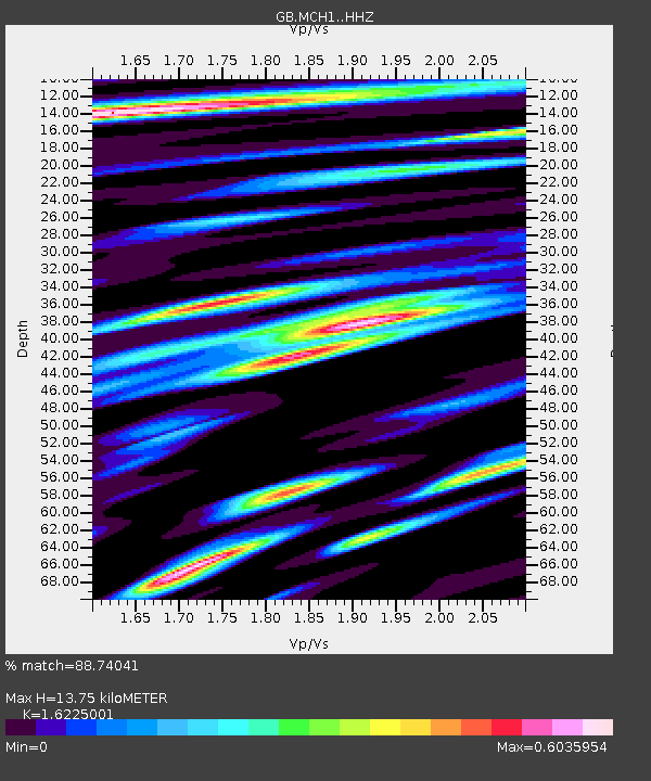
| Estimated Moho Depth: |
13.75 km |
| Estimated Crust Vp/Vs: |
1.62 |
| Assumed Crust Vp: |
6.182 km/s |
| Estimated Crust Vs: |
3.81 km/s |
| Estimated Crust Poisson's Ratio: |
0.19 |
|
| Radial Match: |
88.74041 % |
| Radial Bump: |
400 |
| Transverse Match: |
69.618065 % |
| Transverse Bump: |
400 |
| SOD ConfigId: |
26694651 |
| Insert Time: |
2021-12-12 11:12:24.135 +0000 |
| GWidth: |
2.5 |
| Max Bumps: |
400 |
| Tol: |
0.001 |
|

Signal To Noise
| Channel | StoN | STA | LTA |
| GB:MCH1: :HHZ:20211128T11:04:00.140015Z | 9.208957 | 1.006986E-6 | 1.0934855E-7 |
| GB:MCH1: :HHN:20211128T11:04:00.140015Z | 1.5944382 | 1.5878636E-7 | 9.958765E-8 |
| GB:MCH1: :HHE:20211128T11:04:00.140015Z | 2.8327432 | 2.9241212E-7 | 1.0322578E-7 |
| Arrivals |
| Ps | 1.4 SECOND |
| PpPs | 5.7 SECOND |
| PsPs/PpSs | 7.1 SECOND |


