You are here: Home > Network List > GM - US Geological Survey Networks Stations List
> Station NMP51 New Mexico Permian - Site# W5S1 > Earthquake Result Viewer
NMP51 New Mexico Permian - Site# W5S1 - Earthquake Result Viewer
| Earthquake location: |
Northern Peru |
| Earthquake latitude/longitude: |
-4.5/-76.7 |
| Earthquake time(UTC): |
2021/11/28 (332) 10:52:14 GMT |
| Earthquake Depth: |
99 km |
| Earthquake Magnitude: |
7.4 Mi |
| Earthquake Catalog/Contributor: |
NEIC PDE/at |
|
| Network: |
GM US Geological Survey Networks |
| Station: |
NMP51 New Mexico Permian - Site# W5S1 |
| Lat/Lon: |
32.00 N/103.42 W |
| Elevation: |
975 m |
|
| Distance: |
44.3 deg |
| Az: |
326.852 deg |
| Baz: |
140.086 deg |
| Ray Param: |
0.071666405 |
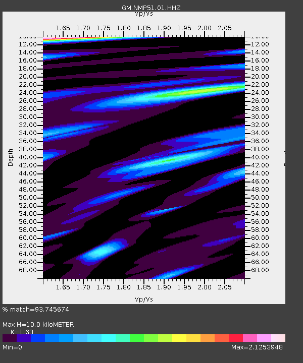
| Estimated Moho Depth: |
10.0 km |
| Estimated Crust Vp/Vs: |
1.63 |
| Assumed Crust Vp: |
6.129 km/s |
| Estimated Crust Vs: |
3.76 km/s |
| Estimated Crust Poisson's Ratio: |
0.20 |
|
| Radial Match: |
93.745674 % |
| Radial Bump: |
400 |
| Transverse Match: |
84.24813 % |
| Transverse Bump: |
400 |
| SOD ConfigId: |
26694651 |
| Insert Time: |
2021-12-12 11:13:01.193 +0000 |
| GWidth: |
2.5 |
| Max Bumps: |
400 |
| Tol: |
0.001 |
|

Signal To Noise
| Channel | StoN | STA | LTA |
| GM:NMP51:01:HHZ:20211128T10:59:43.670013Z | 8.897279 | 5.0340795E-6 | 5.6579995E-7 |
| GM:NMP51:01:HHN:20211128T10:59:43.670013Z | 12.213713 | 2.4208084E-6 | 1.9820413E-7 |
| GM:NMP51:01:HHE:20211128T10:59:43.670013Z | 4.6227145 | 2.0022583E-6 | 4.3313472E-7 |
| Arrivals |
| Ps | 1.1 SECOND |
| PpPs | 4.0 SECOND |
| PsPs/PpSs | 5.1 SECOND |


