You are here: Home > Network List > MU - Miami University Seismic Network Stations List
> Station MUG1 Guernsy > Earthquake Result Viewer
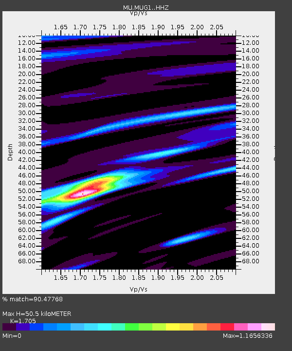
MUG1 Guernsy - Earthquake Result Viewer
| Earthquake location: |
Northern Peru |
| Earthquake latitude/longitude: |
-4.5/-76.7 |
| Earthquake time(UTC): |
2021/11/28 (332) 10:52:14 GMT |
| Earthquake Depth: |
99 km |
| Earthquake Magnitude: |
7.4 Mi |
| Earthquake Catalog/Contributor: |
NEIC PDE/at |
|
| Network: |
MU Miami University Seismic Network |
| Station: |
MUG1 Guernsy |
| Lat/Lon: |
40.11 N/81.29 W |
| Elevation: |
368 m |
|
| Distance: |
44.6 deg |
| Az: |
354.981 deg |
| Baz: |
173.47 deg |
| Ray Param: |
0.071494706 |
| Estimated Moho Depth: |
50.5 km |
| Estimated Crust Vp/Vs: |
1.71 |
| Assumed Crust Vp: |
6.483 km/s |
| Estimated Crust Vs: |
3.802 km/s |
| Estimated Crust Poisson's Ratio: |
0.24 |
|
| Radial Match: |
90.47768 % |
| Radial Bump: |
313 |
| Transverse Match: |
84.54042 % |
| Transverse Bump: |
400 |
| SOD ConfigId: |
26694651 |
| Insert Time: |
2021-12-12 11:16:24.947 +0000 |
| GWidth: |
2.5 |
| Max Bumps: |
400 |
| Tol: |
0.001 |
|

Signal To Noise
| Channel | StoN | STA | LTA |
| MU:MUG1: :HHZ:20211128T10:59:45.839996Z | 15.441347 | 2.5583982E-5 | 1.656849E-6 |
| MU:MUG1: :HHN:20211128T10:59:45.839996Z | 3.7385595 | 7.1450863E-6 | 1.9111872E-6 |
| MU:MUG1: :HHE:20211128T10:59:45.839996Z | 2.522828 | 3.3558847E-6 | 1.3302074E-6 |
| Arrivals |
| Ps | 5.9 SECOND |
| PpPs | 20 SECOND |
| PsPs/PpSs | 26 SECOND |


