You are here: Home > Network List > N4 - Central and EAstern US Network Stations List
> Station S39B Bolivar, MO, USA > Earthquake Result Viewer
S39B Bolivar, MO, USA - Earthquake Result Viewer
| Earthquake location: |
Northern Peru |
| Earthquake latitude/longitude: |
-4.5/-76.7 |
| Earthquake time(UTC): |
2021/11/28 (332) 10:52:14 GMT |
| Earthquake Depth: |
99 km |
| Earthquake Magnitude: |
7.4 Mi |
| Earthquake Catalog/Contributor: |
NEIC PDE/at |
|
| Network: |
N4 Central and EAstern US Network |
| Station: |
S39B Bolivar, MO, USA |
| Lat/Lon: |
37.69 N/93.32 W |
| Elevation: |
340 m |
|
| Distance: |
44.7 deg |
| Az: |
341.189 deg |
| Baz: |
156.095 deg |
| Ray Param: |
0.07140287 |
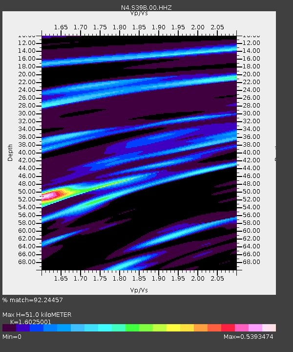
| Estimated Moho Depth: |
51.0 km |
| Estimated Crust Vp/Vs: |
1.60 |
| Assumed Crust Vp: |
6.53 km/s |
| Estimated Crust Vs: |
4.075 km/s |
| Estimated Crust Poisson's Ratio: |
0.18 |
|
| Radial Match: |
92.24457 % |
| Radial Bump: |
342 |
| Transverse Match: |
69.98474 % |
| Transverse Bump: |
400 |
| SOD ConfigId: |
26694651 |
| Insert Time: |
2021-12-12 11:18:18.691 +0000 |
| GWidth: |
2.5 |
| Max Bumps: |
400 |
| Tol: |
0.001 |
|

Signal To Noise
| Channel | StoN | STA | LTA |
| N4:S39B:00:HHZ:20211128T10:59:46.959991Z | 9.0494995 | 4.273119E-6 | 4.72194E-7 |
| N4:S39B:00:HH1:20211128T10:59:46.959991Z | 6.6336603 | 2.2374102E-6 | 3.372814E-7 |
| N4:S39B:00:HH2:20211128T10:59:46.959991Z | 4.8590145 | 1.0249998E-6 | 2.1094809E-7 |
| Arrivals |
| Ps | 5.1 SECOND |
| PpPs | 19 SECOND |
| PsPs/PpSs | 24 SECOND |


