You are here: Home > Network List > N4 - Central and EAstern US Network Stations List
> Station Z35B Perchaven, Sanger, TX, USA > Earthquake Result Viewer
Z35B Perchaven, Sanger, TX, USA - Earthquake Result Viewer
| Earthquake location: |
Northern Peru |
| Earthquake latitude/longitude: |
-4.5/-76.7 |
| Earthquake time(UTC): |
2021/11/28 (332) 10:52:14 GMT |
| Earthquake Depth: |
99 km |
| Earthquake Magnitude: |
7.4 Mi |
| Earthquake Catalog/Contributor: |
NEIC PDE/at |
|
| Network: |
N4 Central and EAstern US Network |
| Station: |
Z35B Perchaven, Sanger, TX, USA |
| Lat/Lon: |
33.33 N/97.25 W |
| Elevation: |
234 m |
|
| Distance: |
42.4 deg |
| Az: |
334.138 deg |
| Baz: |
148.705 deg |
| Ray Param: |
0.0728942 |
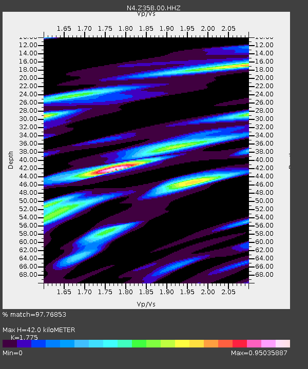
| Estimated Moho Depth: |
42.0 km |
| Estimated Crust Vp/Vs: |
1.77 |
| Assumed Crust Vp: |
6.38 km/s |
| Estimated Crust Vs: |
3.595 km/s |
| Estimated Crust Poisson's Ratio: |
0.27 |
|
| Radial Match: |
97.76853 % |
| Radial Bump: |
297 |
| Transverse Match: |
92.23726 % |
| Transverse Bump: |
400 |
| SOD ConfigId: |
26694651 |
| Insert Time: |
2021-12-12 11:18:57.739 +0000 |
| GWidth: |
2.5 |
| Max Bumps: |
400 |
| Tol: |
0.001 |
|

Signal To Noise
| Channel | StoN | STA | LTA |
| N4:Z35B:00:HHZ:20211128T10:59:27.968994Z | 30.194223 | 1.0770257E-5 | 3.5669927E-7 |
| N4:Z35B:00:HH1:20211128T10:59:27.968994Z | 18.418716 | 4.6642963E-6 | 2.5323678E-7 |
| N4:Z35B:00:HH2:20211128T10:59:27.968994Z | 9.262029 | 4.386712E-6 | 4.7362326E-7 |
| Arrivals |
| Ps | 5.4 SECOND |
| PpPs | 17 SECOND |
| PsPs/PpSs | 23 SECOND |


