You are here: Home > Network List > GM - US Geological Survey Networks Stations List
> Station IWM01 Jericho 2M Well Monitoring Station > Earthquake Result Viewer
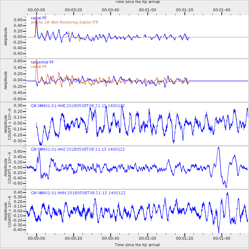
IWM01 Jericho 2M Well Monitoring Station - Earthquake Result Viewer
*The percent match for this event was below the threshold and hence no stack was calculated.
| Earthquake location: |
Gulf Of Alaska |
| Earthquake latitude/longitude: |
56.4/-148.5 |
| Earthquake time(UTC): |
2018/05/08 (128) 08:14:12 GMT |
| Earthquake Depth: |
10 km |
| Earthquake Magnitude: |
5.5 Mww |
| Earthquake Catalog/Contributor: |
NEIC PDE/us |
|
| Network: |
GM US Geological Survey Networks |
| Station: |
IWM01 Jericho 2M Well Monitoring Station |
| Lat/Lon: |
36.73 N/96.53 W |
| Elevation: |
328 m |
|
| Distance: |
39.6 deg |
| Az: |
97.229 deg |
| Baz: |
316.588 deg |
| Ray Param: |
$rayparam |
*The percent match for this event was below the threshold and hence was not used in the summary stack. |
|
| Radial Match: |
57.980347 % |
| Radial Bump: |
400 |
| Transverse Match: |
36.685184 % |
| Transverse Bump: |
400 |
| SOD ConfigId: |
2665671 |
| Insert Time: |
2018-05-22 08:16:43.722 +0000 |
| GWidth: |
2.5 |
| Max Bumps: |
400 |
| Tol: |
0.001 |
|
Signal To Noise
| Channel | StoN | STA | LTA |
| GM:IWM01:01:HHZ:20180508T08:21:13.140012Z | 2.671211 | 2.9196636E-7 | 1.0930112E-7 |
| GM:IWM01:01:HHN:20180508T08:21:13.140012Z | 1.6630712 | 1.5556375E-7 | 9.354005E-8 |
| GM:IWM01:01:HHE:20180508T08:21:13.140012Z | 1.4997095 | 1.9536648E-7 | 1.3026956E-7 |
| Arrivals |
| Ps | |
| PpPs | |
| PsPs/PpSs | |


