You are here: Home > Network List > NM - Cooperative New Madrid Seismic Network Stations List
> Station PENM Penman,Portageville,MO > Earthquake Result Viewer
PENM Penman,Portageville,MO - Earthquake Result Viewer
| Earthquake location: |
Northern Peru |
| Earthquake latitude/longitude: |
-4.5/-76.7 |
| Earthquake time(UTC): |
2021/11/28 (332) 10:52:14 GMT |
| Earthquake Depth: |
99 km |
| Earthquake Magnitude: |
7.4 Mi |
| Earthquake Catalog/Contributor: |
NEIC PDE/at |
|
| Network: |
NM Cooperative New Madrid Seismic Network |
| Station: |
PENM Penman,Portageville,MO |
| Lat/Lon: |
36.45 N/89.63 W |
| Elevation: |
85 m |
|
| Distance: |
42.5 deg |
| Az: |
344.512 deg |
| Baz: |
160.72 deg |
| Ray Param: |
0.072810486 |
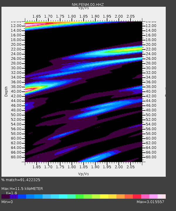
| Estimated Moho Depth: |
11.5 km |
| Estimated Crust Vp/Vs: |
1.60 |
| Assumed Crust Vp: |
6.444 km/s |
| Estimated Crust Vs: |
4.027 km/s |
| Estimated Crust Poisson's Ratio: |
0.18 |
|
| Radial Match: |
91.422325 % |
| Radial Bump: |
400 |
| Transverse Match: |
76.06449 % |
| Transverse Bump: |
400 |
| SOD ConfigId: |
26694651 |
| Insert Time: |
2021-12-12 11:19:41.469 +0000 |
| GWidth: |
2.5 |
| Max Bumps: |
400 |
| Tol: |
0.001 |
|

Signal To Noise
| Channel | StoN | STA | LTA |
| NM:PENM:00:HHZ:20211128T10:59:29.040009Z | 14.08031 | 6.775213E-6 | 4.811835E-7 |
| NM:PENM:00:HHN:20211128T10:59:29.040009Z | 7.250001 | 6.3534644E-6 | 8.763398E-7 |
| NM:PENM:00:HHE:20211128T10:59:29.040009Z | 3.090032 | 3.3688677E-6 | 1.0902371E-6 |
| Arrivals |
| Ps | 1.2 SECOND |
| PpPs | 4.3 SECOND |
| PsPs/PpSs | 5.5 SECOND |


