You are here: Home > Network List > NM - Cooperative New Madrid Seismic Network Stations List
> Station UTMT Martin, TN > Earthquake Result Viewer
UTMT Martin, TN - Earthquake Result Viewer
| Earthquake location: |
Northern Peru |
| Earthquake latitude/longitude: |
-4.5/-76.7 |
| Earthquake time(UTC): |
2021/11/28 (332) 10:52:14 GMT |
| Earthquake Depth: |
99 km |
| Earthquake Magnitude: |
7.4 Mi |
| Earthquake Catalog/Contributor: |
NEIC PDE/at |
|
| Network: |
NM Cooperative New Madrid Seismic Network |
| Station: |
UTMT Martin, TN |
| Lat/Lon: |
36.35 N/88.86 W |
| Elevation: |
110 m |
|
| Distance: |
42.2 deg |
| Az: |
345.331 deg |
| Baz: |
161.777 deg |
| Ray Param: |
0.072994485 |
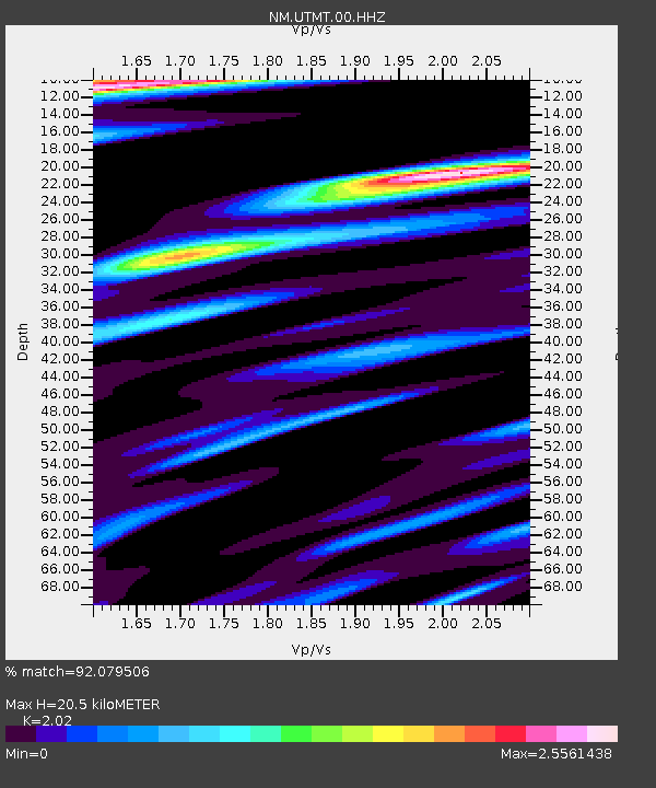
| Estimated Moho Depth: |
20.5 km |
| Estimated Crust Vp/Vs: |
2.02 |
| Assumed Crust Vp: |
6.444 km/s |
| Estimated Crust Vs: |
3.19 km/s |
| Estimated Crust Poisson's Ratio: |
0.34 |
|
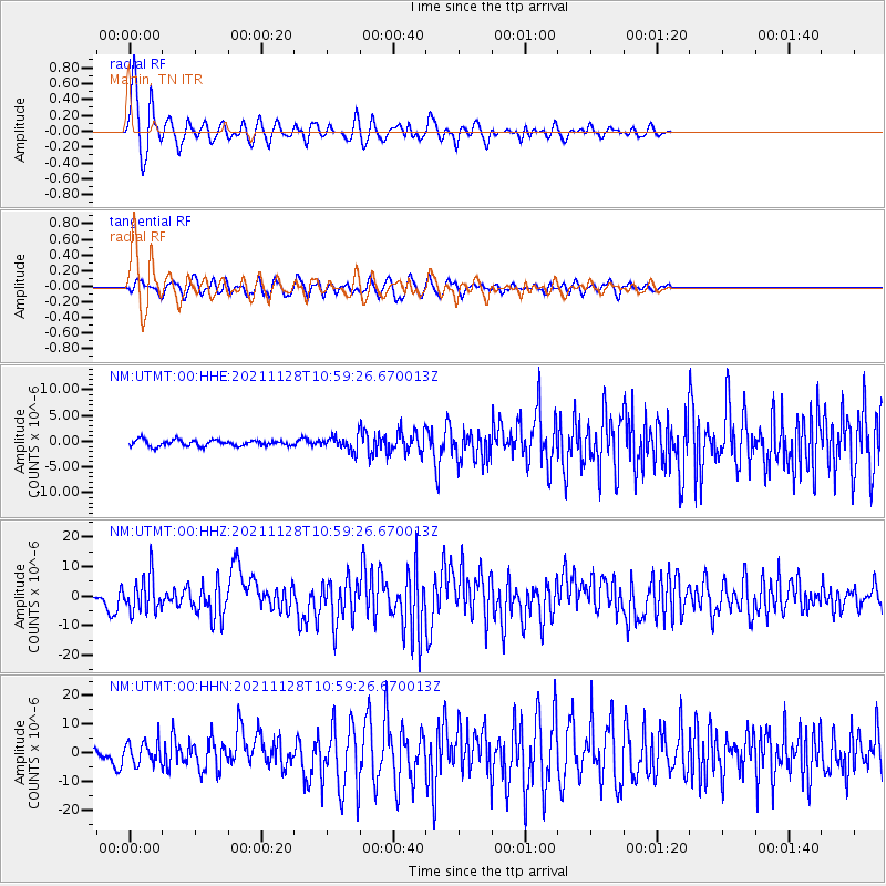
| Radial Match: |
92.079506 % |
| Radial Bump: |
400 |
| Transverse Match: |
78.60304 % |
| Transverse Bump: |
400 |
| SOD ConfigId: |
26694651 |
| Insert Time: |
2021-12-12 11:19:54.560 +0000 |
| GWidth: |
2.5 |
| Max Bumps: |
400 |
| Tol: |
0.001 |
|
Signal To Noise
| Channel | StoN | STA | LTA |
| NM:UTMT:00:HHZ:20211128T10:59:26.670013Z | 11.8408785 | 6.054609E-6 | 5.1133105E-7 |
| NM:UTMT:00:HHN:20211128T10:59:26.670013Z | 3.8907876 | 3.8640646E-6 | 9.931317E-7 |
| NM:UTMT:00:HHE:20211128T10:59:26.670013Z | 2.3698385 | 1.3753904E-6 | 5.8037307E-7 |
| Arrivals |
| Ps | 3.4 SECOND |
| PpPs | 9.1 SECOND |
| PsPs/PpSs | 12 SECOND |


