You are here: Home > Network List > NN - Western Great Basin/Eastern Sierra Nevada Stations List
> Station MCM07 Monte Cristo Menlo 07 > Earthquake Result Viewer
MCM07 Monte Cristo Menlo 07 - Earthquake Result Viewer
| Earthquake location: |
Northern Peru |
| Earthquake latitude/longitude: |
-4.5/-76.7 |
| Earthquake time(UTC): |
2021/11/28 (332) 10:52:14 GMT |
| Earthquake Depth: |
99 km |
| Earthquake Magnitude: |
7.4 Mi |
| Earthquake Catalog/Contributor: |
NEIC PDE/at |
|
| Network: |
NN Western Great Basin/Eastern Sierra Nevada |
| Station: |
MCM07 Monte Cristo Menlo 07 |
| Lat/Lon: |
38.23 N/117.75 W |
| Elevation: |
1716 m |
|
| Distance: |
57.0 deg |
| Az: |
321.945 deg |
| Baz: |
128.712 deg |
| Ray Param: |
0.06347064 |
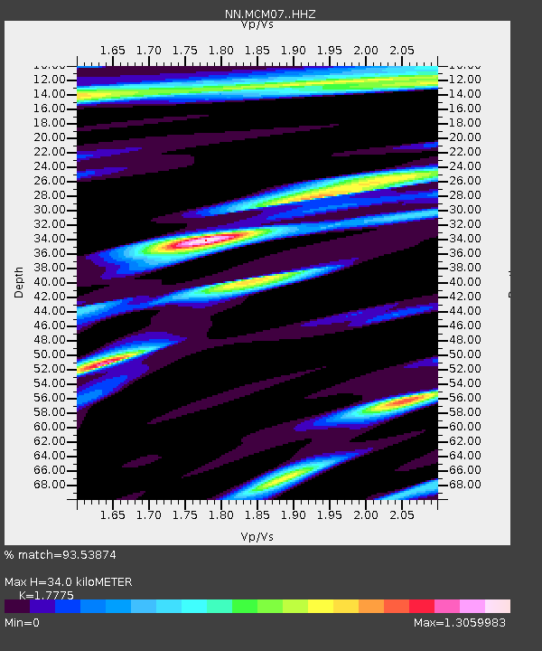
| Estimated Moho Depth: |
34.0 km |
| Estimated Crust Vp/Vs: |
1.78 |
| Assumed Crust Vp: |
6.276 km/s |
| Estimated Crust Vs: |
3.531 km/s |
| Estimated Crust Poisson's Ratio: |
0.27 |
|
| Radial Match: |
93.53874 % |
| Radial Bump: |
400 |
| Transverse Match: |
74.65041 % |
| Transverse Bump: |
400 |
| SOD ConfigId: |
26694651 |
| Insert Time: |
2021-12-12 11:20:16.320 +0000 |
| GWidth: |
2.5 |
| Max Bumps: |
400 |
| Tol: |
0.001 |
|

Signal To Noise
| Channel | StoN | STA | LTA |
| NN:MCM07: :HHZ:20211128T11:01:18.960022Z | 13.894959 | 5.952707E-6 | 4.2840765E-7 |
| NN:MCM07: :HHN:20211128T11:01:18.960022Z | 5.8380756 | 1.4928872E-6 | 2.5571563E-7 |
| NN:MCM07: :HHE:20211128T11:01:18.960022Z | 9.556397 | 1.9175657E-6 | 2.0065781E-7 |
| Arrivals |
| Ps | 4.4 SECOND |
| PpPs | 14 SECOND |
| PsPs/PpSs | 19 SECOND |


