You are here: Home > Network List > O2 - Oklahoma Consolidated Temporary Seismic Networks Stations List
> Station FW07 Waynoka, Oklahoma, USA > Earthquake Result Viewer
FW07 Waynoka, Oklahoma, USA - Earthquake Result Viewer
| Earthquake location: |
Northern Peru |
| Earthquake latitude/longitude: |
-4.5/-76.7 |
| Earthquake time(UTC): |
2021/11/28 (332) 10:52:14 GMT |
| Earthquake Depth: |
99 km |
| Earthquake Magnitude: |
7.4 Mi |
| Earthquake Catalog/Contributor: |
NEIC PDE/at |
|
| Network: |
O2 Oklahoma Consolidated Temporary Seismic Networks |
| Station: |
FW07 Waynoka, Oklahoma, USA |
| Lat/Lon: |
36.45 N/98.80 W |
| Elevation: |
404 m |
|
| Distance: |
45.7 deg |
| Az: |
334.912 deg |
| Baz: |
148.38 deg |
| Ray Param: |
0.07080817 |
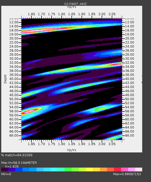
| Estimated Moho Depth: |
56.0 km |
| Estimated Crust Vp/Vs: |
1.63 |
| Assumed Crust Vp: |
6.426 km/s |
| Estimated Crust Vs: |
3.93 km/s |
| Estimated Crust Poisson's Ratio: |
0.20 |
|
| Radial Match: |
94.83308 % |
| Radial Bump: |
400 |
| Transverse Match: |
84.41673 % |
| Transverse Bump: |
400 |
| SOD ConfigId: |
26694651 |
| Insert Time: |
2021-12-12 11:21:44.265 +0000 |
| GWidth: |
2.5 |
| Max Bumps: |
400 |
| Tol: |
0.001 |
|

Signal To Noise
| Channel | StoN | STA | LTA |
| O2:FW07: :HHZ:20211128T10:59:54.434998Z | 11.054428 | 7.2636535E-6 | 6.570809E-7 |
| O2:FW07: :HHN:20211128T10:59:54.434998Z | 5.3400407 | 3.2870873E-6 | 6.1555477E-7 |
| O2:FW07: :HHE:20211128T10:59:54.434998Z | 2.2274203 | 1.5778098E-6 | 7.083575E-7 |
| Arrivals |
| Ps | 5.9 SECOND |
| PpPs | 21 SECOND |
| PsPs/PpSs | 27 SECOND |


