You are here: Home > Network List > O2 - Oklahoma Consolidated Temporary Seismic Networks Stations List
> Station FW09 Waynoka, Oklahoma, USA > Earthquake Result Viewer
FW09 Waynoka, Oklahoma, USA - Earthquake Result Viewer
| Earthquake location: |
Northern Peru |
| Earthquake latitude/longitude: |
-4.5/-76.7 |
| Earthquake time(UTC): |
2021/11/28 (332) 10:52:14 GMT |
| Earthquake Depth: |
99 km |
| Earthquake Magnitude: |
7.4 Mi |
| Earthquake Catalog/Contributor: |
NEIC PDE/at |
|
| Network: |
O2 Oklahoma Consolidated Temporary Seismic Networks |
| Station: |
FW09 Waynoka, Oklahoma, USA |
| Lat/Lon: |
36.55 N/99.04 W |
| Elevation: |
517 m |
|
| Distance: |
45.9 deg |
| Az: |
334.757 deg |
| Baz: |
148.13 deg |
| Ray Param: |
0.070688374 |
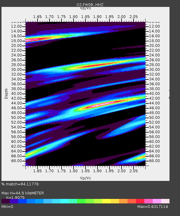
| Estimated Moho Depth: |
44.5 km |
| Estimated Crust Vp/Vs: |
1.91 |
| Assumed Crust Vp: |
6.426 km/s |
| Estimated Crust Vs: |
3.369 km/s |
| Estimated Crust Poisson's Ratio: |
0.31 |
|
| Radial Match: |
94.11778 % |
| Radial Bump: |
387 |
| Transverse Match: |
74.4091 % |
| Transverse Bump: |
400 |
| SOD ConfigId: |
26694651 |
| Insert Time: |
2021-12-12 11:21:46.728 +0000 |
| GWidth: |
2.5 |
| Max Bumps: |
400 |
| Tol: |
0.001 |
|

Signal To Noise
| Channel | StoN | STA | LTA |
| O2:FW09: :HHZ:20211128T10:59:55.899994Z | 16.412973 | 8.440521E-6 | 5.142591E-7 |
| O2:FW09: :HHN:20211128T10:59:55.899994Z | 6.927536 | 3.6631957E-6 | 5.2878767E-7 |
| O2:FW09: :HHE:20211128T10:59:55.899994Z | 1.8077897 | 1.9146396E-6 | 1.0591053E-6 |
| Arrivals |
| Ps | 6.7 SECOND |
| PpPs | 19 SECOND |
| PsPs/PpSs | 26 SECOND |


