You are here: Home > Network List > O2 - Oklahoma Consolidated Temporary Seismic Networks Stations List
> Station SC12 Granite, Oklahoma, USA > Earthquake Result Viewer
SC12 Granite, Oklahoma, USA - Earthquake Result Viewer
| Earthquake location: |
Northern Peru |
| Earthquake latitude/longitude: |
-4.5/-76.7 |
| Earthquake time(UTC): |
2021/11/28 (332) 10:52:14 GMT |
| Earthquake Depth: |
99 km |
| Earthquake Magnitude: |
7.4 Mi |
| Earthquake Catalog/Contributor: |
NEIC PDE/at |
|
| Network: |
O2 Oklahoma Consolidated Temporary Seismic Networks |
| Station: |
SC12 Granite, Oklahoma, USA |
| Lat/Lon: |
34.92 N/99.35 W |
| Elevation: |
472 m |
|
| Distance: |
44.6 deg |
| Az: |
333.224 deg |
| Baz: |
146.868 deg |
| Ray Param: |
0.07146792 |
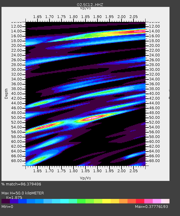
| Estimated Moho Depth: |
50.0 km |
| Estimated Crust Vp/Vs: |
1.88 |
| Assumed Crust Vp: |
6.315 km/s |
| Estimated Crust Vs: |
3.368 km/s |
| Estimated Crust Poisson's Ratio: |
0.30 |
|
| Radial Match: |
96.379486 % |
| Radial Bump: |
354 |
| Transverse Match: |
96.379486 % |
| Transverse Bump: |
354 |
| SOD ConfigId: |
26694651 |
| Insert Time: |
2021-12-12 11:22:31.952 +0000 |
| GWidth: |
2.5 |
| Max Bumps: |
400 |
| Tol: |
0.001 |
|

Signal To Noise
| Channel | StoN | STA | LTA |
| O2:SC12: :HHZ:20211128T10:59:46.170013Z | 20.052715 | 8.049489E-6 | 4.0141643E-7 |
| $trig.getChannelId() | $trig.getValue() | $trig.getSTA() | $trig.getLTA() |
| O2:SC12: :HHE:20211128T10:59:46.170013Z | 9.276899 | 3.525496E-6 | 3.8002958E-7 |
| Arrivals |
| Ps | 7.3 SECOND |
| PpPs | 21 SECOND |
| PsPs/PpSs | 29 SECOND |


