You are here: Home > Network List > OE - Austrian Seismic Network Stations List
> Station KBA Koelnbreinsperre, Kaernten, Austria > Earthquake Result Viewer
KBA Koelnbreinsperre, Kaernten, Austria - Earthquake Result Viewer
| Earthquake location: |
Northern Peru |
| Earthquake latitude/longitude: |
-4.5/-76.7 |
| Earthquake time(UTC): |
2021/11/28 (332) 10:52:14 GMT |
| Earthquake Depth: |
99 km |
| Earthquake Magnitude: |
7.4 Mi |
| Earthquake Catalog/Contributor: |
NEIC PDE/at |
|
| Network: |
OE Austrian Seismic Network |
| Station: |
KBA Koelnbreinsperre, Kaernten, Austria |
| Lat/Lon: |
47.08 N/13.34 E |
| Elevation: |
1721 m |
|
| Distance: |
93.3 deg |
| Az: |
43.202 deg |
| Baz: |
266.974 deg |
| Ray Param: |
0.041242294 |
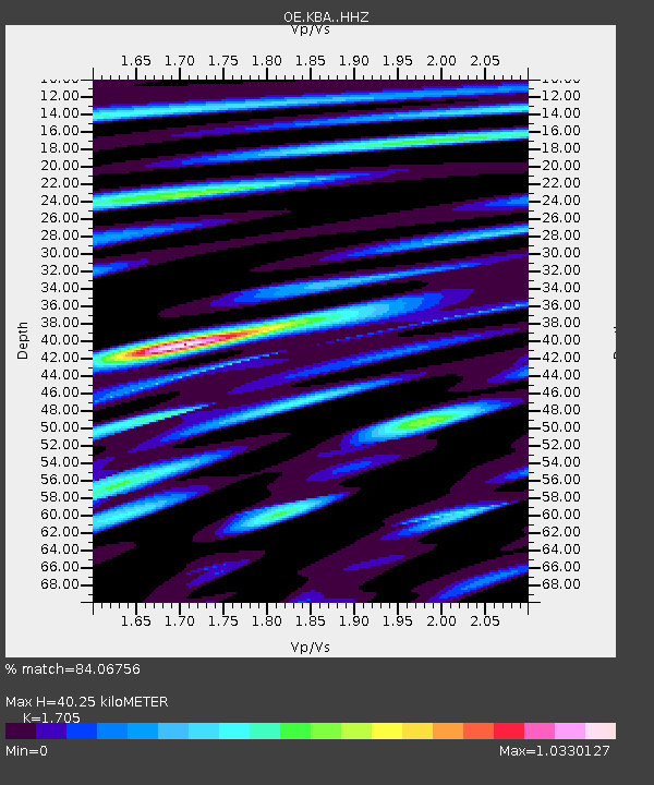
| Estimated Moho Depth: |
40.25 km |
| Estimated Crust Vp/Vs: |
1.71 |
| Assumed Crust Vp: |
6.35 km/s |
| Estimated Crust Vs: |
3.724 km/s |
| Estimated Crust Poisson's Ratio: |
0.24 |
|
| Radial Match: |
84.06756 % |
| Radial Bump: |
400 |
| Transverse Match: |
81.53246 % |
| Transverse Bump: |
400 |
| SOD ConfigId: |
26694651 |
| Insert Time: |
2021-12-12 11:22:54.664 +0000 |
| GWidth: |
2.5 |
| Max Bumps: |
400 |
| Tol: |
0.001 |
|

Signal To Noise
| Channel | StoN | STA | LTA |
| OE:KBA: :HHZ:20211128T11:04:46.348022Z | 11.354974 | 2.2520853E-6 | 1.983347E-7 |
| OE:KBA: :HHN:20211128T11:04:46.348022Z | 2.4666348 | 3.6706254E-7 | 1.4881105E-7 |
| OE:KBA: :HHE:20211128T11:04:46.348022Z | 3.8218484 | 5.756897E-7 | 1.5063122E-7 |
| Arrivals |
| Ps | 4.6 SECOND |
| PpPs | 17 SECOND |
| PsPs/PpSs | 21 SECOND |


